The "Emery Board" terrain survey technique is named after Kenneth O. Emery, a world renowned coastal scientist and geologist. The original Emery Board method was designed for monitoring changes in shoreline topography and could be performed with just two meter sticks and visible horizon; **This adaptation allows you to perform the Emery Board technique in any landscape with elevation change! ** In essence, this is a quick and inexpensive technique for mapping the slope of a land form. Each data point collected during this survey records the distance between the two emery boards (run) and the amount of elevation change that occurs between the two boards (rise). The run is graphed along the X - axis and the rise along the Y - axis, resulting in a cross section map of the area, like the one below. This technique makes it easy to model when, where, and how much terrain changes over time by making repetitive surveys fast and inexpensive. Emery Board survey data can be used in a variety of ways, including mapping sediment movement on beaches following major storm events and measuring spoil banks along pipeline routes in order to monitor industry's permit compliance. ## Activities [notes:grid:emery-board] [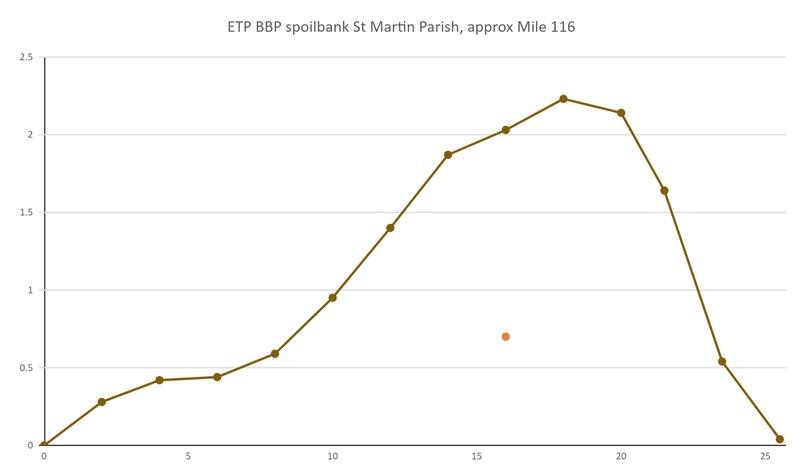](/i/29211) ...
| Author | Comment | Last activity | Moderation | ||
|---|---|---|---|---|---|
| liz | "thanks for explaining this application Scott, i understand it better now. Thank you for all your work! " | Read more » | almost 5 years ago | |||
| stevie | "@stevie awards a barnstar to eustatic for their awesome contribution! " | Read more » | almost 5 years ago | |||
| eustatic | "Update from Naomi. This was a rush build, and crews were still out re-burying the pipeline in late September 2019. The pipeline has been pumping o..." | Read more » | almost 5 years ago | |||
| eustatic | "Update from Naomi. This was a rush build, and crews were still out re-burying the pipeline in late September 2019. The pipeline has been pumping o..." | Read more » | almost 5 years ago | |||
| stevie | "Update: the Emery Board has also been used to measure water depth around pipeline sites " | Read more » | almost 5 years ago | |||
| jonathanbyrgen | " Very interesting study! " | Read more » | almost 6 years ago | |||
| eustatic | "Here's an amazon list of materials, including a different laser level that i think will be less of a hassle I have the craftsman version of this, ..." | Read more » | almost 6 years ago | |||
| eustatic | " Hey, @pataxte, send it to me, i can post it, or just post your comment! thank you! " | Read more » | almost 6 years ago | |||
| eustatic | "@eustatic awards a barnstar to a1ahna for their awesome contribution! " | Read more » | almost 6 years ago | |||
| liz | " This is a wonderfully readable account of how to do this! Thank you so much for writing this up. " | Read more » | almost 6 years ago | |||
| warren | "if you have more trouble, you can email it to me at jeff@publiclab.org and I can try, or at least hopefully figure out why it's not uploading! On..." | Read more » | almost 6 years ago | |||
| xose | "@xose awards a barnstar to a1ahna for their awesome contribution! " | Read more » | almost 6 years ago | |||
| xose | " Hi @pataxte! Things can be making the upload fail: Image too large. Name of the file including blank space or weird character. " | Read more » | almost 6 years ago | |||
| pataxte | "Trying to write a comment on this great post, but attempts to upload an image along with my comment are not working...darn! It's a png file, should..." | Read more » | almost 6 years ago |