Philadelphia
Philadelphia is home to a newly active group of Public Labbers. So far, our focus has been on building a Public Lab community in the Philadelphia region (Philadelphia County; the five-county suburban region in PA; southern NJ; and northern DE) and teaching folks how to organize and run their own balloon mapping projects.
Local organizers
Mapping community engagement in open spaces
Geographers Michelle Schmitt, Megan Heckert, and Dana Bauer launched a project in summer 2013 to explore how Philadelphians use the city's open spaces. The team plans to use balloon mapping techniques and map-based survey tools (like Shareabouts from OpenPlans) to visualize and document community events and gatherings in parks and plazas throughout the city. Possible project sites include: Great Plaza at Penn's Landing, Eakin’s Oval after renovations, FDR Park, Franklin’s Paine Skatepark and Smith PlayPlace. The group hopes to create a replicable process that can be used by anyone to make data-driven improvements to their neighborhood’s public space.
Press coverage: http://planphilly.com/eyesonthestreet/2013/09/05/studying-public-space-usage-via-balloon-mapping
Balloon Mapping Workshop during Philly Tech Week
We will be hosting our second Balloon Mapping Workshop in April 2015 as part of Philly Tech Week. The event is co-sponsored by Azavea and the (GeoPhilly)[http://www.meetup.com/GeoPhilly/] meetup community. Event information can be found here.
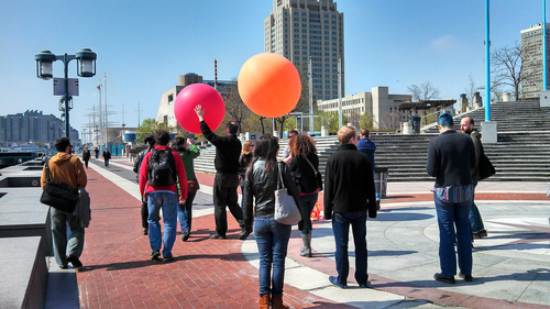
In April 2013, Public Labbers Dana Bauer and Sean McGinnis organized and ran a full-day balloon mapping workshop during Philly Tech Week. Over 20 mapping enthusiast participated and learned about launching balloons, building camera rigs, and stitching images together with MapKinitter. The research note from the event is here: http://publiclab.org/notes/geography76/5-1-2013/balloon-mapping-workshop-during-philly-tech-week-0. Here's the etherpad (hackpad) we used during the event: ph.ly/balloon-mapping.This was the first major Public Lab event in the Philadelphia region. Several community groups and organization backed the workshop: The Hacktory, Hacks Hackers Philly, Philadelphia School District, and the Delaware River Waterfront Corporation. The Hacktory and Hacks Hackers Philly would be ideal hosts for Public Lab events in the region.
We had a train-the-trainer practice session for the workshop facilitators about 10 days before the workshop. The research note for that launch is here: http://publiclab.org/notes/geography76/5-1-2013/launch-washington-crossing-historic-park
Delaware River waterfront mapping
The Public Lab partnered with the Delaware River Waterfront Corporation (DRWC) during the April 2013 Balloon Mapping Workshop. DRWC expressed interest in working with PLOTS on future projects.
Atlantic City
Sean McGinnis launched a balloon at the MAC URISA meeting in Atlantic City in October 2012. The map is here: https://mapknitter.org/map/view/macurisa2012. A gorgeous video of the launch is here: http://georamblings.com/2012/10/video-from-macurisa-conference-balloon-mapping-flight/
Research Notes
The URL for all notes tagged "philadelphia": http://publiclab.org/tag/philadelphia