### About Open-weather is a collective experiment in imaging and imagining the earth and its weather systems using DIY community tools. Co-led by @sophied and @sashae, Open-weather probes the noisy relationships between bodies, atmospheres and weather systems through amateur radio, open data and intersectional feminist approaches to environmental sensing. Open-weather encompasses a series of how-to guides, critical frameworks and public workshops on the reception of satellite images using free or inexpensive amateur radio technologies. When possible, we work with open source software and hardware. Beyond Public Lab, the [Open-weather web platform](https://open-weather.community/) hosts an emerging archive of amateur radio-generated weather images as well as the first Open-weather 'community nowcast' linking 13 citizen ground stations around the world in an effort to engage with the complex relationships between weather and climate change. What do we mean by intersectional feminist approaches to environmental sensing? In Open-weather, we think critically about our 'politics of location' - our different social, economic, historical, geographical and political positions. In doing so we examine how we participate in relationships of power, especially those of white supremacy, in order to better identify and challenge structures of oppression. Through workshops and artistic performances, we bring attention to alternative histories of sensing atmosphere, weather and Earth. We explicitly focus on access to technology and we strive for equity. We ask: who or what gains power from satellite imagery, radio technology, meteorological and climatic data? Finally, we seek forms of sensitivity and responsiveness to the interconnected earth processes that sustain us. ### Location London and low Earth orbit. ### Project history @sophied and @sashae have been working on amateur radio-related projects since early 2017. In 2018 and 2019, @sophied and @sashae collaborated on several public workshops, artworks and writings including the performative script [_Lore of the Radio Fossil_](http://temporaryartreview.com/lore-of-the-radio-fossil/). They designed, coordinated and delivered amateur-radio workshops at the Centre for Research Architecture, Goldsmiths University; the Department of Geography, Royal Holloway University; and the [Royal College of Art, London](http://www.sophiedyer.net/teaching-and-learning/satellite-seance/). In April 2020, they launched Open-weather. From April to December 2020, Open-weather was supported by an interdisciplinary artistic residency at [Akademie Schloss Solitude](http://www.akademie-solitude.de/en/fellowship/fellows/sasha-engelmann~pe4017/), Stuttgart. In Summer 2020 @sophied and @sashae launched the [open-weather.community](https://open-weather.community/) web platform, a central node for the project. [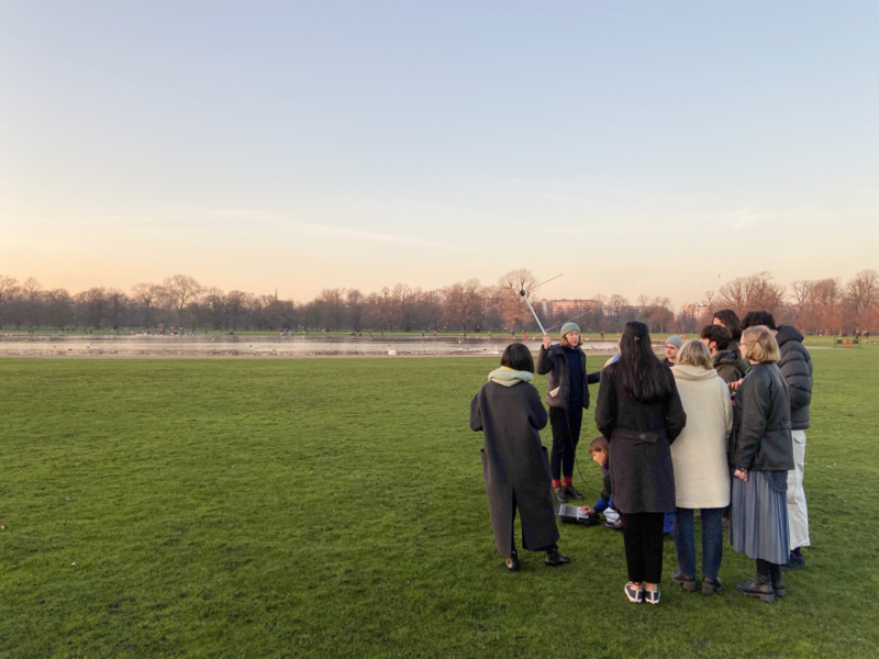](/i/39836?s=o) Open-weather Workshop and Satellite Séance performance at the Royal College of Art, London, in January 2020. @sophied holds the turnstile antenna during the pre-pass talk with @sashae. Photo: Marco Ferrari ### Goals and motivations After @sashae and @sophied got their amateur radio Foundation Licences from the Radio Society of Great Britain it took months of poking around on the web to realise that it was possible to receive weather satellite images, then, more time, searching and hanging out in Ham Radio forums (@sashae is great at this) before they got the right hardware and software setups. Now they’ve done the research and have seen what's possible with inexpensive kit, and they want to share their experience by creating accessible, visually rich how-to guides with everything you need to know to get started, all in one place – without assuming **any** prior knowledge of radio, science or engineering. Goals On Public Lab: * To produce accessible, visually rich and well-documented guides for setting up DIY satellite ground stations for reception of NOAA images. These will be targeted at non-experts (and non-hams). Our hope is that the guides will be useful to curious individuals and practitioners. * To co-author guides that are useful resources for experimental and interdisciplinary teaching and learning at various educational levels. * Discover mutual interests and synchronicities between amateur radio-generated satellite imagery and other kinds of environmental data or projects on Public Lab. On the Open-weather web platform: * To build and maintain a public, amateur radio-generated archive of images and sounds decoded from different satellites, starting from the NOAA fleet, progressing to the Russian Meteor fleet and eventually EU and US-operated geostationary satellites. ### People who are involved Open-weather is a project by UK-based designer @sophied and creative geographer @sashae . The project has been shaped and informed by many others, including: * Bill Liles (NQ6Z) * James Thieman ([Radio Jove/NASA](https://radiojove.gsfc.nasa.gov/)) * Larry Dodd (K4LED) * [Radio Society of Harrow](https://www.g3efx.org.uk/) (G3EFX) * Weather or Not Reading and Listening group * Rachel Dedman, Laure Selys and Arjuna Neuman (Radio Earth Hold) * Daisy Hildyard * The [Soundcamp](https://soundtent.org/soundcamp_reveil.html) 2020 team * The [RTL-SDR Network and Forum](https://www.rtl-sdr.com/) ### What are we currently working on * We are continually working on the [open-weather web platform](https://open-weather.community/) and community archive, initially designed with developer [Piper Haywood](https://piperhaywood.com/). * With the help of the Public Lab community, we are testing our 'DIY Satellite Ground Station' guide (posted in Activities below). * We are developing a series of other accessible how-to guides that extend from the 'DIY Satellite Ground Station' guide and will enable others to further customise and optimise their ground stations. * We are exploring how to make the software ecosystem of NOAA weather data reception more resilient and open source. * We are hosting 1-day public workshops in which participants each create their own DIY Satellite Ground Stations and decode their first NOAA satellite transmission. * We are growing and evolving the Open-weather community network through global weather 'nowcasts' carried out in collaboration with citizen participants at various locations around the planet ### Updates Are you interested in following Open-weather? Subscribe to the tag below to get updates when we post new material. Subscribe to updates on this project [notes:open-weather] ### Questions [questions:open-weather] **** ### Activities we've done in our project [activities:open-weather] ### Data The emerging open-weather archive can be found here: https://open-weather.community/archive.html [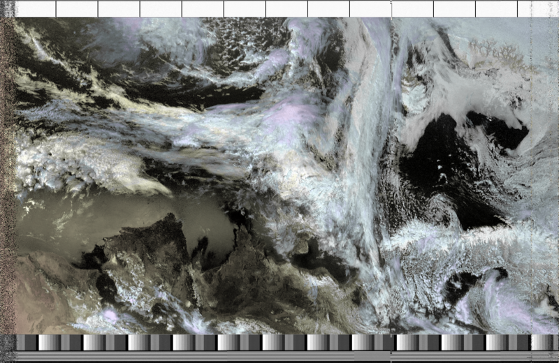](/i/39835?s=o) An image decoded from a NOAA 18 Southbound pass at 49 degrees West on 17th May 2020 at 11-34 BST. Satellite ground station: Burgess Park, South London. ...
| Author | Comment | Last activity | Moderation | ||
|---|---|---|---|---|---|
| lelex76 | "wuau it woulb be great " | Read more » | about 4 years ago | |||
| sashae | "Hi @lelex76 I am not sure what you mean by 'loom' Do you already know about webSDR? http://websdr.org/ " | Read more » | about 4 years ago | |||
| sashae | "Hi @lelex76 , thanks for your question. Are you asking about whether it would be possible to link a radio ground station to the internet along with..." | Read more » | about 4 years ago | |||
| lelex76 | "Rather, it is a haptic signal capturer when weaving from the loom (because it is connected to the coupled system) and those signals (data) are sent..." | Read more » | about 4 years ago | |||
| lelex76 | "I receive suggestions " | Read more » | about 4 years ago | |||
| lelex76 | "and could be one radio wave capture-transmitter system ? and after generate the translation those waves to internet? may be with GPS also? It is p..." | Read more » | about 4 years ago | |||
| lelex76 | "Rather, it is a radio wave capture-transmitter that the loom (the system coupled to it) sends to a specific web " | Read more » | about 4 years ago | |||
| sashae | "Dear @nearsys and @zwettstein (@midmarsh and @usere6020 ) here is the result of the open-weather community nowcast on September 6th 2020. Thanks es..." | Read more » | about 4 years ago | |||
| sashae | "Hi @nearsys and @zwettstein (@midmarsh and @usere6020 too), Thanks for your willingness to contribute to the open-weather global 'nowcast'. Here is..." | Read more » | about 4 years ago | |||
| sashae | "Hi @nearsys and @liz I'm not able to see the image recorded by @nearsys on this thread- would be amazing to see what you got! I would be happy to r..." | Read more » | about 4 years ago | |||
| nearsys | "This is the image I recorded. It looks like the website is locking up when I upload. On Thu, Aug 27, 2020, 8:37 AM \<notifications@publiclab.or..." | Read more » | about 4 years ago | |||
| nearsys | "I used my APT station to record an image of Hurricane Lauren from southwest Idaho. The satellite was going north and only got 35 degrees above my e..." | Read more » | about 4 years ago | |||
| liz | "Hi @nearsys, i got a notification that you got an image of Hurricane Laura yesterday afternoon from southwest Idaho, but i don't see it here on thi..." | Read more » | about 4 years ago | |||
| afzalkhaner | "Nice Post Admin Thanks For Sharing your knowledge Here, keep it up Downnload APKs Free " | Read more » | about 4 years ago | |||
| nearsys | "I got this image of Hurricane Laura this afternoon from southwest Idaho. It looks like that if you remove the cable that comes with the antenna an..." | Read more » | about 4 years ago | |||
| sashae | "Awesome @nearsys ! that's great news. All you need to do is record / decode a NOAA satellite pass on 6th September and submit the images and sounds..." | Read more » | over 4 years ago | |||
| nearsys | "I would like to try. On Tue, Aug 25, 2020, 6:17 AM \<notifications@publiclab.org> wrote: Hi! You were mentioned by sashae in a comment on t..." | Read more » | over 4 years ago | |||
| sashae | "Hey @midmarsh @nearsys @zwettstein and @usere6020: I wonder if you would be interested in participating in a global weather 'nowcast' ? @sophied a..." | Read more » | over 4 years ago | |||
| liz | "Thank you so much for showing how to think through this question @sashae :smiley: " | Read more » | over 4 years ago | |||
| sashae | "Hi @liz, as far as I can tell the Sentinel-5P spacecraft carrying the TROPOMI instrument transmits on the S and X-bands to the ESA ground station i..." | Read more » | over 4 years ago | |||
| sashae | "Hi @nearsys sorry for the delay in replying! @liz thanks for flagging this. @nearsys your image is fantastic and it's wonderful to hear about your ..." | Read more » | over 4 years ago | |||
| liz | "Would TROPOMI (TROPospheric Ozone Monitoring Instrument) http://www.tropomi.eu/ be a satellite that data could be pulled down from in this way? Acc..." | Read more » | over 4 years ago | |||
| liz | "Great image @nearsys! I wonder if anyone else (perhaps @sophied and @sashae ?) might have any insight on the question you asked: Has anyone looked..." | Read more » | over 4 years ago | |||
| todgobblins | "@todgobblins awards a barnstar to sashae for their awesome contribution! " | Read more » | over 4 years ago |