The Public Lab Blog
stories from the Public Lab community
About the blog | Research | Methods

Camp Code: How to navigate a refugee settlement
This blog post is the beginning of an article published at Places Journal on 5 April 2016. It is about Bourj Al Shamali refugee camp and provides background understanding of the situation in the camp where recently a Public Lab Chapter was set up. For the full version of the article (with all the foot notes, photos and links), please refer to original article in Places Journal.

Start with the obvious: not all refugee camps are the same. The experiences of some 60 million people --- "one in every 122 humans," according to the United Nations --- cannot be generalized. They live in tarp shelters, tents, shipping containers, or concrete buildings; in formal settlements administered by the UN, or in makeshift camps on the urban fringe. They are refugees, asylum seekers, stateless, internally displaced. Around the world, their numbers are increasing.
In Lebanon, the crisis (or, rather, series of crises) has been going on since 1948. More than 1 million Syrians and 450,000 Palestinians --- an astonishing one quarter of the population --- live in twelve official refugee camps and hundreds of informal settlements. The oldest camps, once considered temporary, are home to third- and fourth-generation refugees. These are not tent camps but dense spaces of concrete and asphalt, urban materializations of an ongoing state of emergency.
What goes on inside a refugee camp? How is it organized spatially and materially? In these brief sketches, I invite readers to navigate the Palestinian camp of Bourj Al Shamali, situated high on a hill in southern Lebanon, overlooking the Mediterranean city of Tyre. Built as a temporary refuge in 1955, it is now an overcrowded, unplanned, permanent 'city-camp' housing 23,000 registered refugees in 135,000 square meters. It would be easy to drive right past it, mistaking it for a poor district of the adjacent village that shares its name. Seven decades after the camp was founded, what distinguishes the supposedly temporary from the supposedly permanent is anything but clear.

##The Entrance Checkpoint
Your first stop is a Lebanese Army checkpoint on the main entrance road. Foreigners need a permit to enter the camp. It's not hard to obtain, but it takes a few days, and it helps to know someone who can shepherd your request through the mukhabarat, the army intelligence service. The permit system deters curious strangers and helps authorities monitor the population. It also makes the camp feel like an open-air prison. Strict access controls and constant surveillance discourage visits from friends and family members and remind refugees that their life is not entirely their own.
Leaving the camp is easier, at least in tranquil times. You won't trigger any controls, other than a wave from the soldier on duty. But the checkpoint is fickle: it can be strict or lax, depending on current events and the mood of the guards.
Fifty meters down the road is a second checkpoint, run by Fatah. 8 Here a Palestinian soldier stands at attention, hand on his gun, while middle-aged men sit in white plastic chairs, drinking coffee and discussing politics. They don't check papers. At most, you'll get a hard stare. Bourj Al Shamali is one of the quietest Palestinian camps in Lebanon, and these are relatively quiet times.

##Crossing the Border If you don't have a permit, you can still get in. There are five unofficial entrances: former village streets barricaded with cement blocks that allow pedestrians to pass, but not cars. The camp is irregularly shaped, following the property lines of land rented by the Lebanese government for 99 years. Within these borders, the United Nations Relief and Works Agency for Palestine Refugees in the Near East (UNRWA) has provided services since 1955.
When you cross that border, you are in a zone of urban informality. 9 The unplanned streets and haphazard buildings announce that this is a place of legal exception, outside regulation, where a state of emergency is the norm. 10 On every corner you see reminders of the Arab-Israeli conflict: political graffiti, posters of "martyrs" lost in battle, paintings of the Dome of the Rock and of keys that symbolize the properties left behind in historic Palestine.
There is no wall surrounding the refugee camp; in some cases, construction goes right up to the street barricades. On the southern and eastern borders, lush orange trees and banana plantations lie beyond a barbed wire fence.

##Don't Look for a Map On public maps of Lebanon --- paper or online --- refugee camps are often shown as gray blobs, with no detailed view of the street plan. Useful maps of Bourj Al Shamali exist, but they are held tightly by international organizations who regard the circulation of such knowledge as a security risk. That partly explains the unplanned growth. To live without a map is to exist without a future, in a space forever uncharted. Maps of historic Palestine, on the other hand, are everywhere: on flags and banners, walls, keychains, t-shirts. 11
To live without a map is to exist without a future, in a space forever uncharted. There are no signed streets or alleys, either. Here the hill helps you get your bearings, but it's easy to get lost in the jumble of alleys (especially compared to the nearby camps Rashadiyeh and Al Bass, which were built in the 1930s for Armenian refugees and planned by the French on a street grid). The camp is divided informally into neighborhoods named after agricultural villages in the Safad and Tiberias regions of Palestine. When the first refugees arrived, they moved in groups and settled with others from their home villages. 12 Even today, people in Bourj Al Shamali give directions that incorporate landmarks from those old villages. This way of navigating depends on a collective memory of place that is shared even by younger generations who have never visited the referents for the local toponyms.
That shared memory is maintained by groups like Al Houlah Association, which runs the main library in camp. Named after a lake in Palestine that bordered many of the old villages (now the Hula Valley Natural Reserve in Israel), the association aims to reconnect the community with its heritage and to reinforce a sense of civil society. Recently, signs have been installed on houses in camp that report details about the inhabitants' villages of origin.
For more: https://placesjournal.org/article/camp-code/>
Follow related tags:
blog bourjalshamali
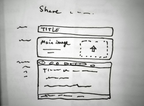
Call for input on upcoming Rich Editor and Rich Wiki projects for PublicLab.org
Hi, all - we're launching a new project for the PublicLab.org website to completely revise the research note posting form based on input from various folks. This summer, we'll launch a similar effort to redesign our wiki pages.
As is always the case in coding, our to-do list could be infinitely long ;-) but I'm hoping to get some of the basic ideas and goals out there in this post, and solicit input and futher suggestions which we'll use to decide on a scope for this project. We're looking to achieve our top goals within a defined timeline, so not everything will be incorporated, but we'll do our best to knock the highest items off the list.
Rich Editor
The Rich Editor project is focused on the following goals, so far:
- easier, more newcomer-friendly posting experience
- clearer prompts/scaffolding for formatting and tagging your work
- tools to encourage authors to invite others into their work
- not overwhelming authors with too much interface
- backwards compatibility with older notes
Some ways we're hoping to address these will most likely include:
- a rich text, What-You-See-Is-What-You-Get (WYSIWYG) editor (possibly using the Woofmark library)
- WYSIWYG image upload and management
- more customized interface for different note types (events, questions, etc)
- modularizing parts of the new editor for re-use by others as an independent library (PublicLab.Editor.js or
npm install publiclab-editor)
Other ideas that could come into play:
- prompting people to describe their work in steps
- prompting for materials/methods -- to enable others to reproduce
- suggested tags interface
- drafts, revisions, better auto-save
- more comprehensive co-authoring
- "write a research note about this" bookmarklet
- inline display of a collection of notes, by tag
Have ideas, want to explore/brainstorm/encourage/caution on any of the above? Please leave a comment!
Rich Wiki
Some of the work on the Rich Editor will likely be re-used in the Rich Wiki project, but wikis are more complex (multiple authors, for one), which is why we're doing this project second.
There's a lot here, and we have more time to plan, but the overall goals are to:
- make the wiki a more collaborative space
- invite more people in to edit/maintain wikis
- make wikis a place to write together, instead of write over one another
- make edits visible to other authors, so they can be discussed
- make it easier to keep wikis up to date and relevant
- make wikis more of a living document -- a place to work together, not to just dump information
Ideas/plans:
- rich/WYSIWYG editing (built on the Rich Editor work)
- commenting and/or in-line commenting
- commenting UI: speech-bubble icon in margin
- "suggest a change" feature, "resolved"
- comment history
- editing of subsections: "edit this section"
- more embedding options like maps, data
- concurrent editing? (difficult but possible)
- "staleness" reminders:
- top of page notice if no edits in X weeks
- email notification to all authors/watchers "this page hasn't been updated in a while. Mark it [out-of-date] [needs-help]"
- listing at
https://publiclab.org/wiki/stale
- more wiki page templates: guides, events, how-to, etc?
- page "Pulse" as Github does for projects, to see a snapshot of collaboration: https://github.com/publiclab/plots2/pulse/monthly
A couple may be completed earlier as they've become a priority due to an increase in spam:
- wiki edit notifications, subscriptions
- wiki page locking
Anyhow, please jump in with ideas -- we'll likely have to break out some features into separate discussions, so I may break out (at least) the Rich Wikis part of this into its own research note, but either way, we're eager to hear from folks!
Follow related tags:
software web blog developers

Environmental Justice and Substantive Policies
The image above is from President Clinton's signing of "Executive Order 12898, an historic directive to federal agencies to address disproportionately high and adverse human health and environmental effects on communities of color and low-income populations." Photo from earthjustice.org, who cite the image to Dr. Robert Bullard.
I wanted to follow up the post I did back in September last year on Environmental Justice in Louisiana. This week past I attended the NEJAC meetings in Gulfport, Mississippi. NEJAC, established in 1993, is the National Environmental Justice Advisory Council, “a federal advisory committee to EPA ... The Council provides advice and recommendations about broad, cross-cutting issues related to environmental justice, from all stakeholders involved in the environmental justice dialogue. ”
To start off the conversation, Gina McCarthy, the US EPA Administrator (think the president’s EPA speed dial contact), began the meeting with comments that “we are here because there are communities left behind.” She highlighted Environmental Justice in its relationship to Public Health, “when the system fails.” While McCarthy is considered, by many, to be progressive in her views of Environmental Justice, many in attendance at NEJAC define EJ issues as not merely in their relation to Public Health, but directly stemming from racism ingrained in our public and private systems.
While we can point fingers at various kinks in these systems where the dirty fingers of racism hold on, many people in NEJAC pointed at the breaking point between state and federal policy. This was specifically referenced at the NEJAC meeting in the state and federal response to the drinking water crisis in Flint. People in Flint had been going to the state on issues of their drinking water for years, and they were ignored. Even when citizens of Flint went to the EPA on the specific issue the EPA deferred concerned citizens back to the state. In fact, it took Virginia Tech, a university in an entirely different state, to bring out this issue through their water sampling in the Flint community. This is the job of the state, and when the state doesn’t do it, it’s the job of EPA to hold the states accountable or intervene and do it themselves.
In analyzing the relationship the Michigan state government has with the term “Environmental Justice” there is as a stark contrast to that of the Louisiana DNR and DEQ as previously discussed. Where you can’t find the words “environment” next to the word “justice” in any state policies in Louisiana, Michigan has at least developed an Environmental Justice Plan, most recently revised in 2010: “Environmental Justice Plan for the state of Michigan and department of Natural Resources and Environment.” (Side note that environmental issues Michigan are now under the Department of Environmental Quality)
In the Michigan state environmental justice plan, the state identifies: “The environmental justice plan among other things, must include measures to identify, address and prevent discriminatory public health or environmental effects of state laws, regulations, policies and activities on Michigan residents. Discriminatory effects are those that cause disproportionately adverse public health or environmental impacts on minority or low income populations...As with any state government agency, the DNRE must carry out its responsibilities in compliance with federal and state laws and agency regulations prohibiting both intentional and unintentional discriminatory actions based on a number of protected categories, including race, color or national origin. Furthermore, recommendations of of the plan include “prioritizing inspections, enforcement, compliance assistance, remediation and other activities which assist in identifying and mitigating disparate impacts.”
While we might expect that states who don’t even recognize Environmental Justice in their governmental agencies might be worse at protecting EJ communities, it had been unclear to me if states that do highlight EJ issues might be better. This is by no means an analysis, but based on what is happening in Michigan, it seems that even when the state recognizes the problems of environmental injustice, it does not necessarily follow that EJ communities are more protected, or even that the paths between people and policy, or metrics of accountability are more clear.
As previously mentioned in the EJ in LA post, the EPA has been putting forward tools such as EJScreen, and others in helping to identify vulnerable and subjugated communities. But as highlighted by the EPA, “EJScreen simply provides a way to display this information and includes a method for combining environmental and demographic indicators into EJ indexes.”. In the NEJAC meeting, renowned EJ advocate Vernice Miller-Travis (former Director of the Environmental Justice Initiative of the NRDC, former Executive Director of Groundwork USA, co-founder of We ACT for Environmental Justice) argues that beyond resources, and beyond engaging people in public participation, we need “substantive policies,” policies with teeth that direct responsibility and take action.
So while it’s great that Michigan had an EJ working group back in 2010, where are the substantive policies? While it’s also great that the EPA creates tools such as EJScreen and the new DWMaps, where are the substantive policies? And while we are told by US EPA Office of Water’s Deputy Assistant Administrator Joel Beauvais that (an estimated?) 9% of drinking water systems in the US are not meeting health based water quality regulations, where are the substantive policies?
Follow related tags:
blog environmentaljustice ej law-and-policy

DIY Oil Testing Narratives
This is an article by Ann Chen for Community Science Forum Issue #1 on DYI Oil Testing. Buy a copy in the Public Lab Store.
Through a Homebrew Sprint Fellowship, I have spent the last few months working with Gretchen Gerke, Public Lab’s Data & Advocacy Steward on gathering stories from within the Public Lab community and beyond to develop use case examples for when the Oil Testing Kit could be useful. Many of these stories came from the Gulf Coast region and center around oil contamination of land and water. Landfill runoff, oil spills from transport and extraction, or leaks from machinery and equipment are just a few of the examples given by the people I interviewed.
Scott Eustis, from the Gulf Restoration Network (Louisiana) and also a longtime Public Lab member and organizer identified three specific sites of potential oil contamination that come from very different sources. With some help from Stevie Lewis, I connected with Margie Vicknair, an environmental activist and long-time Gulf Coast resident about the history of the oil and gas industry in Louisiana. It was shocking to learn from her how many pipelines crisscross the state and how some of the older pipelines, built by companies that no longer exist, probably aren’t even correctly mapped.
What was most striking for me was how similar her stories were to the ones related to me by many of the people I spoke with in northwestern Canada where I’ve been researching the impacts of oil and gas industry projects on local communities. Margie’s story about her older brother returning from a hunting trip with stories of animal skeletal remains around an abandoned pit reminded me of the many stories I heard from First Nations people of returning from hunting trips with poisoned fish or moose. Margie’s stories carried a similar urgency as those I heard from northern communities in Alberta and British Columbia. Her plea was for greater accountability. Margie hopes companies will create responsibility reports on oil spills.
Donovan Cameron, a GIS Advisor for Saulteau First Nations in northeastern British Columbia, who oversees environmental and cultural monitoring programs of his traditional territory spoke of the challenges his environmental monitors face when collecting physical data of oil leaks from surveying equipment used by oil and gas companies on their land. An Oil Testing Kit would be a helpful addition to the photographic imagery they are collecting. The purpose for gathering these stories is to provide real-world examples for people interested in using the oil testing kit in the wild. In the last few weeks left of my fellowship, I will use this time to think about the shared stories that exist across regionally different communities, tied together by similar environmental consequences of oil and gas development.
Follow related tags:
louisiana blog oil-testing oil-testing-kit
Mapping Rural Alberta's Wetlands
Background
Alberta, Canada, has a great deal of land area in wetlands and has fairly strong laws in place to protect those wetlands. Despite those protections, wetlands are illegally drained and filled-in each year, mostly for conversion into farmland, but also for development projects of all kinds. Alberta's provincial government has a department in place to handle permitting of wetland modification and to levy fines against unpermitted modification. Satellite imagery is readily available, and despite its age (several years) can serve as a historical record of the land's state. A ground-based photo can make it obvious that a particular wetland area has been modified, but aerial photography provides much better evidence. Drone-base, kite-based, or balloon-based photography can be used to quickly generate aerial imagery that reflects the current state of a wetland (or former wetland).
Goal
I would like to come up with a quick method to map wetlands. Once a wetland is mapped, it is protected from illegal modification, in the sense that a modification can easily be shown to the authorities. By examining historical satellite imagery, a motivated citizen could set out to map areas that may have been modified and use the resulting imagery as evidence for the authorities. To be clear, I'm not sure that this is something I want to do personally, but I have no problems helping to seed some local knowledge that could enable this sort of action.
Although I can see a fixed-wing drone as an efficient tool for mapping large areas, my dog ate the expanded polystyrene RC plane that was serving as my drone test-bed. Besides, I would like to promote a tool that is accessible to as many as possible. Drones demand a technical aptitude that isn't common and are expensive compared to a kite-based mapping kit. Worse, RC plane- or quadcopter-based drones suffer from a stigma that could complicate conversations with curious observers or concerned land-owners. A kite-based tool is far less concerning to most.
My attempt and results
I have obtained a Public Lab's Kite Mapping Pack, which contains a 7-foot Hi Sky Delta, a 9-foot Dazzle Delta, and a 15' fuzzy tail. 1000-feet of 150-pound Dacron line was ordered separately and recently arrived, although most of my testing to date was using 400' of 125-pound test nylon cord (from our local farm store).
Both kites have been out for about ten test flights in a variety of conditions without a rig. In low wind conditions I have been consistently surprised at how acceptable air is found above 100'.
My experience with the kites has been positive over-all. The 15-foot fuzzy tail is always attached to the centre loop if there is enough wind to allow it. I wouldn't attach a camera rig to either kite without the fuzzy tail in place at this point. The Dazzle seems to move around much less to the Hi Sky in similar winds. The Dazzle also flies at a much higher angle than the Hi Sky in similar winds. Just a bit too high, in my opinion.
I do feel it is worth mentioning that the Dazzle Delta has a habit of pointing its nose at the ground and staying so until it the Earth stops it. This occurs in stronger winds with or without a tail. Letting out line is a possible fix, although I have not been able to test this yet.
Given appropriate wind conditions for the Dazzle, it is by far the better KAP platform as it flies higher and with much less motion.
A line reel has been constructed from some plywood and skateboard wheels. It works acceptably, but is over-built and not properly balanced. Reeling in a kite when there is decent wind is still tiring. Letting line out can get exciting too.
My camera rig is based on the Kaptery's Redstone Rig. I have used locally available replacements for fasteners and the fibreglass rod.
For now, my KAP camera is a Canon SD1100 IS with CHDK firmware installed. After three kite-mapping sessions, I find the quality to be acceptable. The motion of the camera as it hangs from the kite usually limits the quality of photographs to below the capability of the camera. Out of about 500 images, only a couple of dozen have been as sharp as the SD1100 allows. At this point, a better camera probably isn't justified.
Next steps
Another 1000 feet of kite line would be useful as it will allow high-altitude images that cover a large area of land. These images are very useful in MapKnitter, greatly easing the warping of lower-altitude higher detail images.
Figuring out how to lock my camera's settings to a particular exposure is necessary. Currently, the camera's automatic exposure creates images that are wildly different. A software tool to post-process the images to better match would also be useful.
A tool-chain to remove blurry images, correct lens distortion, crop away the outer third of images (reducing perspective issues), and bring a set of images exposures into alignment, is a necessary prerequisite to making really decent MapKnitter maps.
More experience with kites is definitely required. A kite-enthusiast meet-up would be hugely useful.
A stabilized rig might greatly increase the number of useful images that can be obtained in a given amount of flight time. If so, it would allow a better camera to be used.
A Levitation Delta from Into The Wind may be in my future.
Follow related tags:
kite-mapping wetlands blog canada

Guilin Pharma mapping
What I want to do
First time we try to apply the Balloon and Kites Mapping tools on investigating environmental issues in China. We wanted to conduct our aerial photography shooting at a pharmaceutical factory in Guilin, hope to see what it was like inside the pharmaceutical plant, how the sewage system worked and if there were any illegal activities going on in the plant.
Research Background
Guilin, located in Guangxi Zhuang Autonomous Region, is one of the most popular tourist attractions in China, which is world-famous for its peculiar Karst landform. Most of the tourist guidebooks about China put Guilin on the must-visit Lists.

Photo from chinatravelca
There is an interesting fact about Guilin, however, rarely mentioned. Guilin Pharma is an important pharmaceutical production base for the Active pharmaceutical ingredients of artemisinin, for which Mrs. Tu Youyou received the Nobel Prize in natural sciences as the first laureate officially recognized by the Chinese authorities. It was a former state owned pharmaceutical plant originally called “Guangxi Province Guilin City Pharmaceutical Plant”.
After the reforming and overhauling of state sector in 2004, there has been constant media coverage about how this pharmaceutical plant has been polluting the environment. The plant and the residential area next to it are only separated by a wall. The industrial sewage and the urban rainwater are both discharged into the same sewage system. The residents are suffering from water and air pollution greatly. Last year in May, there was black water coming out of the sewage wells and the whole compound was covered in smelly water. Residents in this compound are mostly retired workers from former state-owned enterprises. The current owners of those companies don’t care about them anymore.

Mr. Yang Chaojin, whose livelihood is depended on fish farming, contacted 20 acres of fishponds to farm fish in 10 years ago. In 2014 all of the fish he farmed died over night. He was convinced that it was because of the sewage water the plant had been discharging into the ponds. He has been trying to quest for answers from the plant in the past couple of years. As an attempt to avoid trouble, the plant gave him 5000rmb in total as compensation. According to what he told us, fish wouldn’t survive in those ponds anymore so now he is farming duck instead.

My attempt and results
One day before we shot the aerial photos of Guilin Pharma, we did a trial run on another pharmaceutical plant called Guilin Huaxin Pharmaceutical Plant. Guilin Huaxin has similar sewage and air pollution issues like Guilin Pharma and it has taken a toll on the local living around the plant.
There was this particularly weird wind draft so we got two plans. We could fly either kites or balloons.
Liz had already set up pendulum rig on the train. Zhang Zhang attached vinyl to the camera for protection. We downloaded the mobius application at the hotel and set the camera onto auto pilot mode so it would automatically take a picture every 5 seconds.
We got our hands on a bottle of helium from a Chinese New Year decoration store . Though the volume was not specifically clarified or marked on the bottle. Liz didn’t think even think it was pure helium in the bottle . Still it was enough for blowing 5 rubber balloons ( around 80cm in diameter ) and 12 foil balloons ( around 40-50cm in diameter).


We failed to fly the kite since the draft was not strong enough and there were a lot of electric wires around. So we decided to switch to balloons.
Approximately 12 of those foil balloons could barely hold up one stick pendulum rig.
While we were flying the balloons, many people passed by and looked at us. Later on we found that there was a funeral going on in the neighborhood . But we still flew the colorful balloons in the sky while the funeral was on.
After spending 5 minutes in the air, the balloons got caught by some electric wires and exploded. We were really shocked. The camera was blown away. Just when we were about to leave, another balloon got blown onto another wire and it caused a second explosion. Luckily nothing more serious happened. We were truly lucky since we didn’t use hydrogen. It was one of the possibilities we considered while we were shopping for a bottle of gas.


( Later we happened to see a similar scene on Breaking Bad Season 3)

We found the camera on a roof.... and found the lens cap was not taken off....
We tried a different approach afterwards. We tied the camera on the top of a long bamboo stick and stuck it over the fence wall of the pharmaceutical plant. We got this photo.

Shizi, our environmental engineer suspected that the blue barrels were dumpsters for hazard wastes. We didn’t obtained more valuable information other than that.
Afterwards we practiced flying the kite near Guilin Pharma. The wind was blowing in the opposite direction to the plant . We only got to take photos of one corner of the pharmaceutical plant and many photos were blurry. We assumed it was because the sky was a bit dark and the shutter speed was too slow. ( However we couldn’t set the shutter speed on the application).

It wasn’t too windy the next day. The first thing we did was to buy two bottles of helium . This time we used rubber balloons instead which made it possible to pump in more gas. Then we went to Yang Chaojin’s.
First we went for 5 rubber balloons with 2 foil balloons . It was strong enough to lift up the device. Since it was noon, the automatic shutter speed was pretty ideal and the photos were not blurry.


Liz suggested that we should use more balloons and we went for it. The wind direction was pretty good. We used 2 reels of threads and the balloons went like 800 to 1000 meters away (little dot in the sky).
Photos we've got:
Moses are growing in Those sewage pools ( three rectangular pools) . It looks like they have been out of service for a pretty long time.

A full view of the pharmaceutical plant : surround by mountains, great physical features.

https://mapknitter.org/embed/guilin-pharma
the world-famous Shitou Hill of Guilin is right next to it.
It was quite a thrilling process retrieving the balloons.
After we got the balloons back, we found that the threads tiding to the balloons were almost cut through. We couldn’t come up with an explanation but suspected that it got scratched by some tree branches.

We ARE happy :) Kim: Documentary photographer Liz: Chinese Love Liz Barry! Shizi: Environmental engineer, expert on water quality Zhangzhang: Educational product designer Shan(me): Chinese Green NGOer

Another mission of the trip is eating.
Questions and next steps
Still not sure if it's safe to publish those aerial photo in China, also trying to figure out effective ways to help victims to improve their living environment. Will do some communication work after Chinese New Year. We need to improve our flying skills, and find some good kites.

After mapping, we give all our balloon to the fisherman, to let his home look better
Follow related tags:
balloon-mapping blog asia barnstar:watchdog