Classification
Classification refers to categorizing or classifying parts of an image into different types, for example pavement, water, soil and sand. It often relies on examining an image pixel by pixel and using color or shape information to decide which "class" is the best match. The result is often an image such as this one, which is colored by class:

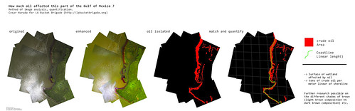
If classification can be automated, using for example the software program GeniePro, large numbers of photos or large maps can be colored by class, helping to quantify for example "how much wetlands?", "how much oil?" or "how much Spartina alterniflora?"
Spectral classification
Using the ratios of Red, Green, and Blue (and possibly Near-infrared), spectral classification attempts to categorize regions of an image by land type.
Read more in this post by Adam Griffith and students at Western Carolina University
Open source classification software
- Spring - desktop app, not super user-friendly (see a tree canopy project using SPRING by Diane Styers)
- Clashifier - web service, in planning stage, not functional