What I want to do

Freshkills Park, formerly a landfill, is under invasion!!! An invasive plant species known as phragmites is slowly starting to creep into the park. This type, believe to have arrived from Europe, has a nasty habit of killing all plant life around creating a monoculture. Freshkills Park has spent a great deal of effort in reclaiming the former landfill by importing fertile soil and reintroducing native plant species. Phragmites is attempting to undo all of this. Furthermore, the head high plant creates other potential issues including being a potential fire hazard and possibly disturbing the landfill cap. Phragmites as seen in this picture, is growing up through the pavement!
My attempt and results
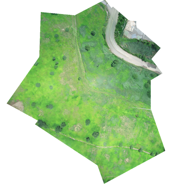
Using balloon photography, we attempted to map a small area of the park in order to identify where phragmites is growing. From overhead, phragmites is a dark green color which is distinctly different from the lighter green and yellowish plant life which is currently growing on the park mounds.

We also ventured to the Norther Mound Wetlands where a restoration process has been taking place over the last year. Mapping the area show's clearly there is no phragmites in the area!!
Lessons Learned
It is important to contact the FAA if you are within radius of an airport. While mapping, we had a helicopter constantly flying by narrowly avoiding the balloon. Fortunately, he was based nearby and we were able to inform him of our work. A close call...


8 Comments
Wow, interesting! You're pretty confident about the ability to recognize phragmites from the air? Where are your MapKnitter projects -- could we try to add annotations to show some samples of where they are or are not?
Is this a question? Click here to post it to the Questions page.
Reply to this comment...
Log in to comment
We werent sure at first but the color differences between the phrag and other grasses is pretty distinct. I uploaded a second annotated image. And we actually used photomerge on photoshop to stitch these photos together. True it doesnt have a map layer behind it but was much easier to get a better merge. Any strong opinions on this? Also, we're not too sure what the next steps with the project should be. The park is huge and it would take a long time to map everything...
Is this a question? Click here to post it to the Questions page.
Reply to this comment...
Log in to comment
Oh, it's fine to use whatever works for you of course! I just wanted to see the comparison and a label for the phragmites is a great way to illustrate it, thanks! I also wasn't sure which map was which. The top one which you didn't provide labeling for is the one which shows no phragmites, right?
Is this a question? Click here to post it to the Questions page.
Reply to this comment...
Log in to comment
I've labeled everything now! Both maps actually have phrag though the North Mound Wetlands area has been designed to keep phrag out...which it seems to be doing a good job.
Reply to this comment...
Log in to comment
Very interesting approach. I admire you for it so that you care for the environment.
Reply to this comment...
Log in to comment
Great Images!
Reply to this comment...
Log in to comment
There's an issue with older posts' lead images currently, but these are still a couple interesting previous cases of attempts to examine plant species in a wetlands area or on water:
http://publiclab.org/notes/cfastie/4-3-2013/multispectral-defelice http://publiclab.org/notes/cfastie/07-29-2013/waterchestnut-nrg http://publiclab.org/notes/code4maine/06-25-2014/kap-test-for-invasives-monitoring-project
by @cfastie and @code4maine -- just wanted to connect the dots!
Reply to this comment...
Log in to comment
looping in @Adam-Griffith for his wetland plant ID skillz
Reply to this comment...
Log in to comment
Login to comment.