What I want to do
September 27, 2014
This note documents Eymund's dye tracing experiments at two sites.
Site 1: new wetlands on edge of the salt lot

Eymund showing that the dye--as proxy for sediment--reveals that constructed wetlands should not exceed 6' from the edge of the bulkhead/bank:


Site 2: hypothesized Vechtes Brook flowing into Gowanus through landfilled 5th Street Basin
Approaching the site --


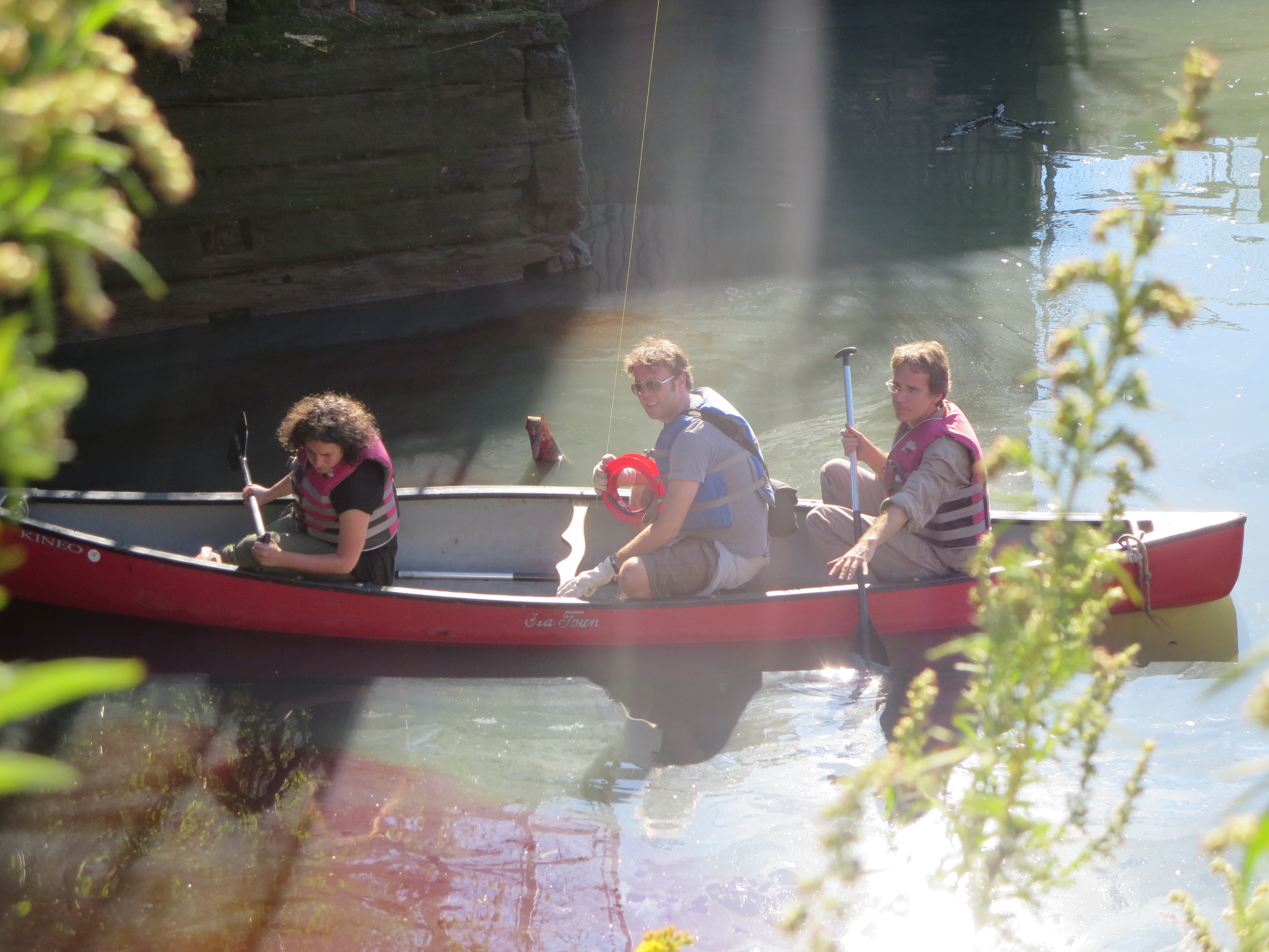
@bronwen pouring in a gallon of red dye:

Studying flow patterns:


Results
FROM ABOVE: The dye goes in:

The dye is clearly visible from the balloon, which is important for future attempts, but it seems like the path of the canoe disturbs the path of the dye.


Next steps
We will repeat this experiment with a two tethered balloon held by canoers, but with the dye released by someone standing under the bridge where the inflow can be clearly observed.
Why I'm interested
The discovery of flowing groundwater at the 1st street basin is altering both federal EPA and municipal DEP restoration and management plans. We want to continue research along these lines.
5 Comments
Canoes shouldn't create eddies that penetrate very deeply into the water current.
Did the dye penetrate into the water or rest on top? If the dye floated on top, you might want to increase the dye's density by dissolving some salt into the dye (it sounds like there's already plenty of salt in the water). Dye that is submerged might be harder to see in diminished concentrations, but it might follow currents better. Warm enough water should surface as it reaches colder water, so you might even see a dyed swell downstream a bit.
Is this a question? Click here to post it to the Questions page.
Reply to this comment...
Log in to comment
Talking about density, temperature, and floating makes me think of a Galileo thermometer: they are sealed with little glass beads that show the temperature.
You might be able to capture some of the water from the injection site, seal it in some kind of neutrally bouyant bob, and drop that bob in the water. You'll probably never see the bob again and thus pollute the river with objects. I'm not really sure this particular density concept goes anywhere helpful now that I've written it.
Reply to this comment...
Log in to comment
Photo featured here: http://plannerspointing.tumblr.com/post/98902068918/september-27-2014-eymund-diegel-discussing-the
Reply to this comment...
Log in to comment
Thanks for the comments on dye density !
Because the dye was largely freshwater being poured into brackish saltwater it tended to float on surface.
We observed three general dye dispersion patterns from the tests:
The tidal currents were outgoing when we ran the tests, and were a major variable in how fast the dye patterns spread. At the First Street Dentons Spring site we noted that the dye went much further out into the Canal than at the Second Avenue Conservancy wetlands site. Both sites are now being affected by the much higher permanent currents from the Flushing Tunnel, which is artificially pumping over a quarter million gallons per day of East River Water into the Gowanus Canal.
Think of the Gowanus Canal not just as a homogeneous pint of vanilla ice cream, but as a swirly mix of chocolate and vanilla, or water currents of different strengths and patterns. (Yum ?)(http://blogs.villagevoice.com/forkintheroad/2014/07/ample_hills_gowanus_location_is_now_open.php)
Where and how these currents function affects how sediments are deposited in the bottom of the Canal, and how the Canal's natural tendency to revert to a shallow tidal wetland will function.
Map showing historical reconstruction of stream outflows (Vechte's Brook and Denton's Spring) we were studying:
The implications for the Superfund ecosystem restoration discussion is that the edge of the 2nd Ave Salt lot, because of current strengths, may only support a narrow strip of mud flats necessary for natural wetland regrowth. The First Street Basin area, because of the bend at Carroll Street causing eddies, will support wider wetland mudflats.
The end of the Fourth Stream basin seemed to be the most promising, showing a tendency for dye to drift northwards, meaning the shoreline of the Whole Food's Park will be more prone to the natural resedimentation that is conducive to tidal wetlands emergence.
27 September 2014 Balloon aerial showing wetland mudbanks naturally reemerging on southern edge of the Whole Foods site:
The main problem which the red dye test showed was that the strength of Vechte's Brook's fresh water flow is too anemic to have a substantial impact on the Fourth Street Basin's stagnant's water quality. Based on putting an ear to the ground, listening for the sound of streams through storm grates, the bulk of the Vechte's Brook is speculated to be diverted into the 4th Avenue combined sewer at 2nd Street.
The Fourth Street Basin site provides a unique opportunity to restore a historical stream that played a critical role in the 1776 Battle of Brooklyn, and provide a safe Greenway walk to school for local school children currently having to cross Third Avenue.
Our food dye testing is not the first time the restoration of the landfilled Fourth and Fifth Street Basin and a more natural stormwater management and stream restoration has been discussed:
(an 1885 article referring to Fourth Avenue and Carroll Street flooding)
"These houses are built on low ground, and the kindness of the contractor in making a public dump of the vacant lot in front of them has so arranged matters that the rain water from the lot in question and also from the property between there and Third avenue flood into them. When it rains, they are flooded, and the surface drains become a nuisance instead of a help, the drains are so elevated that the ends of the perimeter are actually lower than the ends of the street.
Connection with the canal which is only sixty or a hundred feet away, would remove all the trouble."
9 May 1885 A TOUR THROUGH THE THIRD DISTRICT Some Objectionable Italian Tenements and Pestilential Dumping Grounds THE CONDITION OF BROOKLYN'S STREETS AND HOUSES. Brooklyn Daily Eagle,
You can explore the topic of Lost Rivers and urban stream restoration further here: http://vimeo.com/50839044
Is this a question? Click here to post it to the Questions page.
Reply to this comment...
Log in to comment
Some samples of the dye dispersion patterns as seen from the balloon camera:
Vechte's Brook - Bronwen running pour tests..
Dentons Spring
We discovered that depending on where you are on the Canal, currents and sediment deposition patterns either hug the shore, or will swirl out into center of Canal.
The water patterns of the Canal shoreline of the main branch Canal (eg: Salt Lot Area) seem to favor narrow "strip" wetlands, whereas areas with shoreline bends (the 30 degree bend at Carroll Street Bridge, the 90 degree side basin ends) seem to support sediment accumulation favoring larger "blob" wetlands.
Reply to this comment...
Log in to comment
Login to comment.