
WHAT'S IN A GHOST SWAMP?
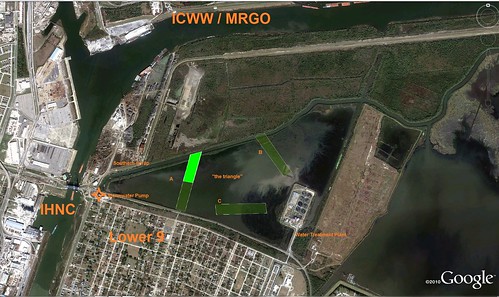
One goal of the Green Slice goal is to make an annotated map of Bayou Bienvenue to show geographic relationships within the wetland environment.
Bayou Bienvenue represents a collapsed swamp; a "ghost swamp." the MR-GO shipping channel allowed much salt water to enter the bayou area in the late 1960's. Only the stumps of the freshwater cypress trees remain. The ponded area known as the "triangle" represents what remains of the former drainages of bayou bienvenue and logger bayou. The former channel of Bayou Bienvenue itself has been straightened to accomodate a drainage canal for the section within our slice. It is the 'hypotenuse' of our triangle. A scrap metals recycling station is a source of metal contamination to the northwest, and a drainage pump pumps stormwater from the southwest. A wastewater treatment plant produces soils and freshwater on the eastern edge of the triangle, the parish line between Orleans and St Bernard parishes. It is a source of nitrogen.
KMZ link
Within our slice is a ~15 acre section of the "triangle" pond, 2000ft long and 350 ft wide, extending from the river into the triangle along the continuing path of Caffin Ave. Although this place seems "featureless", and defined by what used to be present, there are currently some features to describe:
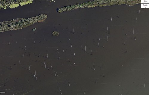
dead cypress stumps
patches of salt marsh vegetation
patches of fresh marsh vegetation (if there are any)
algal mats
birds and fishes —their location and frequency
extent of submersed coontail vegetation
We certainly think that restoration of the triangle pond will improve the ecosystem functions of the area. We seek to measure changes to show changes and improvements.
There is also some value in mapping the actual cypress stumps, as these will likely be removed or avoided in order to conduct the dredging and fill operations that will move clean sediment into the area to build up the land to allow fresh marsh and cypress trees to flourish once again.
There may also be value in mapping the newly filled wetland assimilation area, designed to test our assumptions about the ability of wetlands to take up and denitrify the excess nitrogen from the wastewater plant on the parish line. I've marked that on the map
There may be value in simple desktop classroom excercises
—can we enumerate how many stumps there are in google earth pro / google maps? per acre? can we project this density to estimate how many in the entire triangle?
—are there areas with higher stump density that will affect restoration operations?
--What does the density of stumps tell us about appropriate goals for restoration?
But beyond the desktop, the experience of physically mapping the area will give us a sense of space but also a sense of place within it.
MAPPING A "FEATURELESS," FLAT WATERSCAPE
one issue with mapping landscapes like ponds is that they lack regular features to anchor the photo, to help us knit the aerial photos together. As there are some techniques for "ground control points", mapping bayou bienvenue may benefit greatly from "water control points"— markers at water level that enable us to swiftly tie the locations to the content of the photos.
In Louisiana, as always, the aquatic nature of the landscape presents a challenge-- how to have floating control points? Because we have balloons and string and tape available, breath-inflated balloons tied to stumps, in a particular pattern, seem the cheapest method on hand to produce a floating, waterproof, colorful control point.
Because we learned in a previous mapping effort that the Ghost trees present a challenge to manipulating a balloon, the balloon may have to be operated at a lower height. this does have its advantages though, as it provides a higher-quality resolution map.
Using our 13 foot canoe as a measuring stick from the previous (failed) low-altitude mapping effort, we can estimate that each photograph will be about 100 x 150 ft.
With Shannon as pilot, we may be able to overcome this limitation.
 [canoe moving across large algal mat]
and so, we need about 20 x 3 = 60 balloons across our landscape.
So we can tell one row of balloons from one another, we will alter the colors in a rotating pattern— red blue yellow, yellow red blue, blue yellow red, etc, to more easily distinguish the rows from one another.
We can target a particular area, half our slice with 30 balloons to start. [main picture]
Balloons can be spaced during the control point placement outing, then georeferenced using the same Garmin GPS unit. We'll try this on Friday.
As a point of reference, the mirage drive kayaks move at 3-4 mph, covering 2000 feet in 10 minutes.

5 Comments
Scott, if you inflate the balloons only halfway they might last longer. If that makes them too small, use two or more. The number of balloons could be used in the coding to identify which is which, although that could fail if some pop or deflate.
Reply to this comment...
Log in to comment
Good idea, Chris.
the color pattern might change, too--perhaps a center line of one color, then alternating rows of different colors?
Is this a question? Click here to post it to the Questions page.
Reply to this comment...
Log in to comment
Pictures of actual
Placement
foot anchor while placing balloons
map of actual coming soon
Reply to this comment...
Log in to comment
Reply to this comment...
Log in to comment
Does anyone know why the balloons shrink in the water?
Is this a question? Click here to post it to the Questions page.
Reply to this comment...
Log in to comment
Login to comment.