(with: Ned Horning, Ben Gamari, Laura Dietz, Jeff Warren, Galen Fastie, and Chris Fastie at SNOWFEST)
What I want to do
Characterize the extent of the thermal plume that extends outward from the Plymouth power plant into Cape Cod Bay. Here's a Google Map of where it's located:

My attempt and results
At SNOWFEST, a local aquaculture enthusiast and LANDSAT historian suggested looking at thermal imagery in the LANDSAT archive corresponding to the geographic area around the Plymouth nuclear power generating plant.
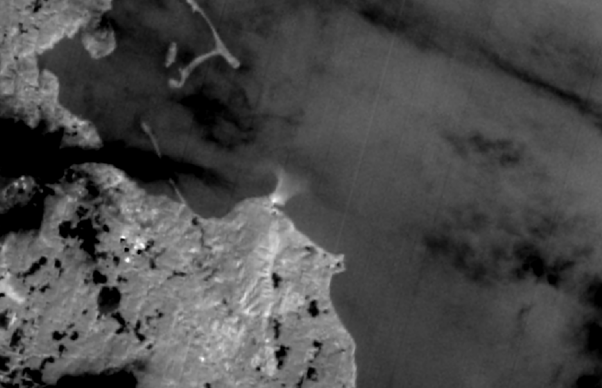
LANDSAT-8 acquires thermal imagery every 16 days of the same location; we visited http://glovis.usgs.gov in order to find the most recent LANDSAT-8 image that wasn't obscured by cloud cover: 2014-01-13.
Here's a zoomed-in Google Map screenshot:

... and here's the LANDSAT-8 imagery from the 'thermal' part of the spectrum (for reference, this was "Band 11"). In this image, the brightness of the pixels corresponds to temperature (brighter = warmer):

You can clearly see the spatial extent of the thermal plume -- you can click on the above image to zoom in.
Questions and next steps
The satellite instrumentation is calibrated such that we're able to determine the temperature of individual pixels from their brightness levels, according to a formula -- we're looking into how we might derive an actual temperature for the plume.
We'll be aiming to go through this process again soon, and we'll try to better document the process of downloading imagery from the "glovis" site.
Why I'm interested
The Plymouth plant's cooling system ejects heat into the Cape Cod bay, and this post demonstrates a possible way of characterizing the spatial extent of thermal plume.
8 Comments
Any way to include a temperature scale reference?
Is this a question? Click here to post it to the Questions page.
Reply to this comment...
Log in to comment
Nice work you guys!! Was the plant running on the day that this image was taken? Since the plant has been going up and down recently It might be interesting to correlate the satellite image/s with the plant's uptimes & downtimes and see if we can find out how long the thermal difference persists and whether it's stronger when the plant runs continuously for longer periods of time.
Is this a question? Click here to post it to the Questions page.
Reply to this comment...
Log in to comment
It would be cool to see these in false color?
Is this a question? Click here to post it to the Questions page.
Reply to this comment...
Log in to comment
Haha -- http://infragram.org to the rescue!
Reply to this comment...
Log in to comment
Hi @karenv and Pine, can you refresh my memory on what regulatory agency is in charge of permitting the volume and temperature of water released by the nuclear power plant? Basically, who were we trying to reach with our data?
Is this a question? Click here to post it to the Questions page.
Reply to this comment...
Log in to comment
Hi Liz - It's mainly EPA, but we could also reach out to state DEP as well.
Reply to this comment...
Log in to comment
thanks @karenv . Did you make any postings about how the actual meeting with EPA went where you called for more regulation over this thermal plume? I am interested in how the advocacy effort went and if there are any ways we can seek to improve it next time around.
Is this a question? Click here to post it to the Questions page.
Reply to this comment...
Log in to comment
This letter contains a good overview of what has happened so far with EPA (see the background section). http://www.capecodbaywatch.org/wp-content/uploads/2014/01/NPDESLetter_Final_2014Jan28.pdf We have specifically been trying to get the NPDES permit updated (which would bring about an updated env'tal assessment of the cooling system, including the thermal pollution among other issues). As of last month, we are now asking for the facility to be shut down considering all the missed deadlines by EPA to renew the permit. We just posted this recently: http://www.capecodbaywatch.org/2014/07/close-pilgrim-its-the-only-way-to-stop-entergy-from-using-the-bay-as-a-dump/ and are asking people to take action and contact EPA and their legislators. In addition to this, there has also been advocacy targeting NMFS based on impacts of plume on endangered species - I'll send you a chronology document of that work by email...too much to type out. Hope that helps!
Reply to this comment...
Log in to comment
Login to comment.