The Friends of Penobscot Bay are pleased to announce the renewal of our 'Stockton Harbor Sundays' field investigations! Please join us every Sunday at the land end of the the Sears Island Causeway between noon and 3pm. June 22nd through August 31st. Come see first hand what is possibly the worst coastal acidification site in the United States, as well as nearby Sears Island, New England's biggest wild undeveloped public land island, at the far end of the causeway. Plenty of free parking along the Sears Island Road & causeway Directions below.
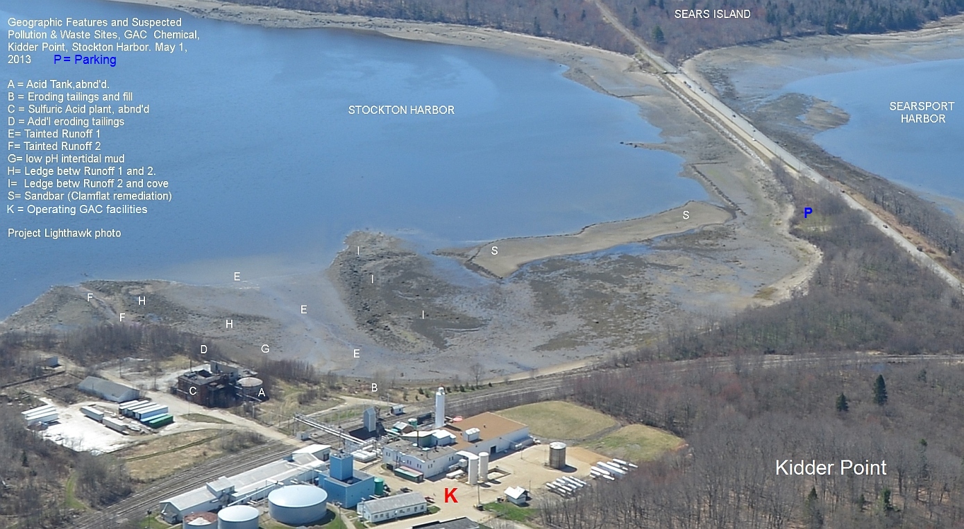
WASTE PLUME MUD MAPPING Onsite: On Sunday June 22nd, noon to 3pm join Ron Huber and other Friends of Penobscot Bay at the middle of the Sears Island Causeway in Searport, Maine. There we'll hold a short briefing of the industrial history of the two harbors split by tyhe casuseway while we view the entire polluted cove adjoining Kidder Point, amid a vista of greater Stockton Harbor, Sears Island, Searsport Harbor, and Kidder Point's petroleum port neighbor Mack Point
Next, we'll walk across nearby low tide Kidder Cove - a public beach-rimmed intertidal cove between the Sears Island Causeway. We will note the changing ecosystem as we approach the contaminated waste-eroding tip of the Kidder Point peninsula.
Here, FOPB want to re-map* the extent of the waste plumes' visible advance into the intertidal cove's mud since last the plume was visually last mapped in 1998 by Maine DEP. Depending on the tide's procession We will start from either the visibly contaminated sediments at the beach/mud interface closest to the eroding waste shore, and proceed in several lines out into the cove observing how far from land the discoloration patches extend into the flats and how deeply.
Testers moving along staked transects will both demarcate photograph and GPS plot both wastes already visible on surface and those just below the surface.
* Remapping the site. In 1998, Maine DEP's then-marine ecologist John Sowles did a snapshot qualitative examination of this location. In his May 7, 1998 email to MDEP Land & Water Quality staffer Clarissa Trasko & myself, Sowles noted: "The sediment itself is a discolored off-white creamy color in small patches up to a meter square. Just under the surface, over an area comprising about an acre, similar discolored sediment is found. Overall depths of the discolored material varied from a few millimeters to several (10) centimeters. Below the discolored material, a typical anoxic (black) sediment is found.The texture of the discolored material is similar to mud/silt,having a high water content. The origin of the material is probably from historic spills and slumping banks and chemical piles .An eroding slumping enbankment is immediately landward of the altered flat. This is filled land, and according to Alec [Alec Horth, then-manager of the General Alum plant], contains a creamy/light rose colored bauxite. Presumably the beach and flat contains this same material." End of excerpt.
Maine DEP's Lee Doggett also examined the site and wrote this review
Has the waste plume shrunk? Grown? Let's find out!
Directions From downtown Searsport head north on Route 1 about 2 miles to Sears Island Road on right. Follow S.I. Road about a mile to the causeway. From Bucksport, go ten miles south on Route 1 to Sears Island Road on left. Follow a mile to causeway
Option: Use Google Map directions to "Sears Island, Maine"
Note small parking area downhill on left just before causeway The entryway to the contaminated cove is at the lower end of this dirt parking lot If lot filled, parking is OK on side of Sears Island Road (and along sides of causeway Bring gloves to safely touch or pick up objects from inner cove. Bring rinse water for hands and footwear before reentering you vehicle.
0 Comments
Login to comment.