Satellite Environmental Monitoring / Request for Site Nominations
Introduction As part of Public Lab’s Google Summer of Code program, software tools (Image Sequencer/MapKnitter). will be enhanced to display and process satellite imagery. This note request locations of sites of interest that will be used as test images.
Program Description : This project seeks to increase environmental awareness by demonstrating the different ways to collect, process and combine satellite imagery with neighborhood environmental data. Areas nominated by the Public Lab community will be selected for analysis. Ideally, the same locations will also be observed by Public Lab Balloon/Kite cameras and other ground sensors. The objective is to develop ground truth monitoring to assist satellite measurements and for satellite sensing to guide ‘near earth’ based measurements. Three sites will be selected for analysis using Planet and LandSat 8 satellite data from May 27 to August 1. At the end of the project, the tools will be available for any and all sites that people wish to analyze.
Ares of interest will be selected based on:
- Environmental benefit
- Supplemental ‘near earth’ based high resolution imagery from balloon/kite cameras or other measurements that help calibrate satellite imagery.
- Interest in helping interpret satellite images with respect to environmental science.
How to nominate: Provide comments to this post with the following info:
- Provide latitude and longitude (image center).
- Geometry of image area (coastal linear strip, square, etc)
- Brief description of reason for study (pollution monitoring, restoration, agriculture, deforestation, global warming, red tide/algal blooms, etc)
- Contact info (Ideally by Public Lab, @ name)
- Optional: List prior Public Lab work
- Optional: Possible supporting measurements/references
Satellite Description:
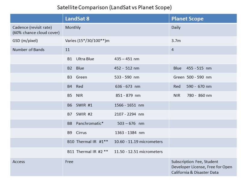
LandSat 8 and Planet satellite systems provide medium resolution images and have global coverage. Comparison of Planet and LandSat 8 satellite features are provided below:
 Example satellite images
Representative satellite images are posted of the Bayou Sauvage Wildlife Preservation in Louisiana. The images display initial display/processing options for the same scene. Please recommend more advanced processing options as potential program upgrades.
- Planet Multiband Display / NDVI processing
- LandSat 8 Multiband Display
- Planet time analysis useful for change detection:
- Other examples available at: https://mapknitter.org/profile/maggpi
Example nomination:
- Location: Bayou Sauvage Wildlife Preserve, LA
- Latitude: 30.0502715433
- Longitude: -89.8365047898
- Geometry: Square area, outline of preserve, 10km x 10 km
- Goal: monitor restoration progress
- Contact info: @name (public lab) or email
Public Lab measurements: https://publiclab.org/notes/eustatic/04-01-2019/mapknitter-map-of-usfws-restoration-wildlife-habitat-bayou-sauvage-linear-planting and https://publiclab.org/notes/eustatic/6-23-2012/h2s-strip-placement-bayou-sauvage-nwr-orleans-parish-la
Reference: https://lacoast.gov/new/Projects/Info.aspx?num=PO-16
Additional Information:

5 Comments
@silentsairam would you have any interest in this?
Is this a question? Click here to post it to the Questions page.
Yes @warren . This is quite interesting and the satellite methodology approach would be more precise in mapping. I would be happy to explore more once I am getting my hands more dirt with Mapknitter first.
With respect to the place I live in, Lakes, treemap, vegetation could be mapped with satellite images and also keep informed both people & govt. to devise an action plan.
Reply to this comment...
Log in to comment
@eustatic or @a1ahna ?
Is this a question? Click here to post it to the Questions page.
Reply to this comment...
Log in to comment
Using the ultra blue Band 1 from LandSat 8, I created a video showing how to apply the NDVI to Landsat-8 images using QGIS. The tiles are from the California coastal area near Monterey (36°49'32.6"N 121°47'10.6"W) .
https://youtu.be/SSDbFL0juyk
Reply to this comment...
Log in to comment
To @cagiva, I applied the same NDVI technique to Nottingham UK planet.com satellite imagery; you can see the results on Mapknitter:
https://mapknitter.org/maps/nottingham-ndvi--3
Thank you for your video and QDIS reference. Had to make adjustments for QDIS 3.6 but it works great ...
Reply to this comment...
Log in to comment
Login to comment.