
MapKnitter map of bee leg stitch test
I did this Help out by offering feedback! Browse other activities for "microscope"
People who did this (0)
None yet. Be the first to post one!
I did this Help out by offering feedback! Browse other activities for "microscope"
None yet. Be the first to post one!
5 Comments
This is a test of Public Lab's MapKnitter online program to 'stitch' microscope imagery (instead of map features). The image is a 13 picture mosaic of a honeybee leg. ( For more info on resolution: https://publiclab.org/notes/MaggPi/06-23-2018/microscope-calibration-overlays-what-s-the-best-approach. or https://publiclab.org/notes/MaggPi/06-05-2018/usb-webcam-vs-raspberry-pi-v2-field-of-view-fov-comparison-community-microscope-initial-evaluation-2 )
Scroll in/out to see the different 'leg' features!
The test demonstrates how MapKnitter can scale/project other pictures beside aerial photos.
If anyone knows how to start with a grid or blank background (instead of a map) please make a comment.....
Reply to this comment...
Log in to comment
This is so great! I'll have to give this a shot. To work with a blank (looking) background in Mapknitter you can select the Open Street Map layer and then zoom in until you've zoomed past any labeled features, (if you do this over the ocean or rural area you won't have to click as many times). You can get a beige-ish (over land) or blue (over water) background this way. You can delete the latitude and longitude info, unless you'd like to try to match your location info with the place where your sample was collected or your own location.
If you zoom all the way on the satellite view you end up with kind of blurred grid, but if you prefer a grey background you can zoom in on Open Street Map and then toggle over to the satellite view-- then you just get a blank grey background instead of the blurred photo.
Update: can't delete the Lat/Lon, which means these will end up geographically located to SOMEWHERE.
Reply to this comment...
Log in to comment
These are really nice bee images. If your goal is to make a seamless composite, the free Microsoft ICE (Windows only) will stitch the photos into a single image and blend them together.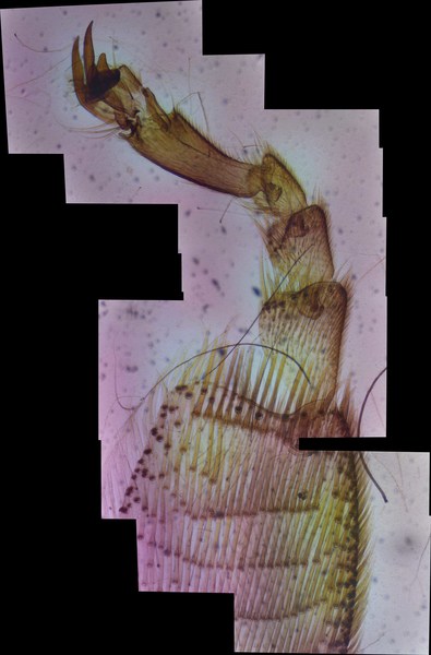
This seemed to reveal that there is a narrow slice without coverage. ICE will fill in missing parts of an image:
ICE doesn't do much else, so it's really easy to use.
Chris
Reply to this comment...
Log in to comment
The ICE auto alignment and fill in features are impressive and super cool. Still, I like MapKnitter since it lets you zoom in/out. I think that's really important since microscope lenses force you to pick between resolution or field of view. Once you make the mosaic you can have both by scrolling thru the image. Of course, you could probably do the same thing with an ICE Image by adding a separate viewer.
Right now, I am trying to compare different stitching programs to see how they work. My list so far is MapKnitter, ICE, ImageJ, Adobe photomerge and opencv stitcher. If you know of any reviews that compare performance of different stitching programs I would be interested. Thanks again for your help.
Also added some more frames to the initial mapKnitter post so you can see more of the bee leg.
Reply to this comment...
Log in to comment
I absolutely love this idea @MaggPi !! I agree with you, the zoom / scrolling ability makes this feel a lot more interactive, like looking into a real petri dish. I also really like the artistic component of microorganisms overlaid on a macro satellite image of the area the sample was collected from, and now my brain is teeming with ideas for other artistic applications of MapKnitter
Reply to this comment...
Log in to comment
Login to comment.