Ted and myself, Cindy will be hosting a two-part workshop on kite-mapping and map-making in London. Briefly, Part 1 is using kites to gather aerial imagery; Part 2 is making maps from the images collected using mapknitter.org. Join us!
DIY Aerial Mapping Part.1 – Let’s fly kites!
In this 2.5 hr workshop we'll roll-up our sleeves and learn about DIY aerial photography and how to use a kite to collect aerial imagery. Everyone will get to fly a delta kite (320 cm wing span) and attach the cameras to the kite line. Alongside the practical aspects, the session includes conversations about the methods and ethos of DIY, Public Lab, implications of aerial mapping, representation, inclusion, and privacy. We will also share stories of how aerial mapping has been used to address issues of social & environmental justice around the globe. This session also includes the technical and safety bits of DIY kite mapping!
NOTE: No prior experience required. NOTE 2: If you are interested in mapping a specific area please do not hesitate to tell us! Send me an email to arrange for a site visit.
When: 2 - this event is weather-dependent. We will send you more information approx. 2 wks before the event.
Where: Regent's Park - the Hub [map here]
Who: Everyone 5 y.o.+ welcome!
What's next: DIY Aerial Mapping Pt.2 - Let's make maps! at 4PM
What to bring (this is important!):
• a fleece or/and wind breaker;
• sunglasses (we'll be staring up at the sky a lot!);
• sunscreen and/or hat (that won't fly away!);
• a water bottle;
• a notebook
~~~~~~~~~~~~~~~~~~~~~~~~~~~~~~~~~~~~~~~~~
DIY Aerial Mapping Pt.2 – Let’s make maps!
In this 2-2.5 hr workshop we'll roll-up our sleeves and learn how to make a composite aerial photograph from the images collected in the previous workshop using the grassroots webtool MapKnitter. Learn how to interpret aerial photos, their uses, and examples of how/where DIY mapping has been used around the world (including how this all began during the BP oil spill in the Gulf of Mexico 2010). NOTE: No prior experience required.
When: Saturday June 27th, 4PM; Also repeat on Sunday June 28th 1PM
Where: UCL, Chadwick Building, room 217
What to bring (this is important!): a laptop computer (good to have but not absolutely necessary we can pair up); a USB memory stick 4GB or bigger to store aerial imagery
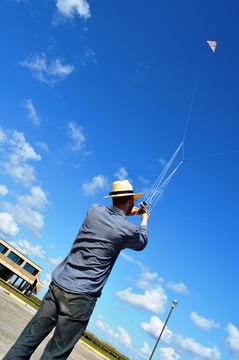
[Image - Mathew flying Barney, the DIY Delta kite made at the 2012 Barnraising in Cocodrie, Louisiana]
2 Comments
I will be attending!
Reply to this comment...
Log in to comment
@Cindy_ExCites can we communicate by email? I missed your workshop but wanted to ask you questions. mikeytomkins at g mail dot com.
Is this a question? Click here to post it to the Questions page.
Reply to this comment...
Log in to comment
Login to comment.