Unearthing Providence
A platform for historical data-driven analyses of industrial land use, story-mapping, and community organizing.
Welcome to Unearthing Providence
, an interactive website designed to encourage and support public environmental history, local story mapping, and community organizing. Join us! [add link]
WHAT WE DO. Unearthing Providence brings urban history to life by recovering lost knowledge about past land uses in Providence and Rhode Island and making this information publicly available. We work to forge and strengthen relationships with Rhode Island community and social justice organizations, schools, and other academic and government partners in striving to build a more equitable, just and sustainable future for all Rhode Islanders.
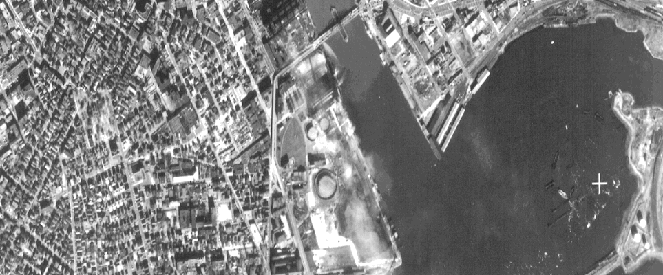
HOW WE DO IT. The heart of our project is an interactive map featuring site-specific data about every manufacturing facility that has operated in Rhode Island since the early 1950s. Soon, we will add historical information on other environmentally risky land uses such as gas stations, dry cleaners, and auto repair shops, as well as “green” land uses like urban parks, playgrounds, schools and community gardens. Using the data to inform historical analyses of data trends and in-depth studies of featured sites, these data promise to deepen public understanding of socio-ecological change in one American city and state over the past century.
Add photos and memories to help tell the story of these sites and their legacy.
Featured sites
The industrial sites cataloged include both currently operating and long-closed factories, jewelry manufacturers, gas stations, laundromats, and many other land uses, which may have a lasting impact on the land.

Recipes for Dyes: Chemicals, Metals, and Acids at Cranston Print Works
Post by @srgonsalves1 0 | over 4 years ago


Analyses
A collection of in-depth research and analyses of the database are presented here, providing examples of the kinds of work the dataset makes possible.


Where do the data come from?
We use computational techniques to extract information from historical manufacturing directories and old city directories. From these data, we can identify where industrial and other environmentally risky land uses occurred in the past, investigate how the same sites are being reused today, and identify potential sources of legacy contaminants.
Here’s a short video that explains our basic approach:
Our data collection efforts are ongoing and can be replicated in other cities and states. Technical information on data sources, coding, and data management for academic and government researchers can be found at the Brown Digital Repository
The full dataset is available here (GeoJSON format, 4.6mb)
Relationships
One interesting part about the project we’ve developed is that it can be used as a foundation for new storytelling projects, which overlay narratives or new datasets on top of the industrial sites database (above).
By being a part of the Public Lab network, this project links into dozens of other local environmental projects around the world, as well as a range of environmental topics of concern and the grassroots communities of interest that have formed around them.
Here are some of the projects which have built on the Unearthing Providence dataset:


About the project
The Socio-Ecological City Project (SECP) is an intensive data collection effort focused on assembling a comprehensive longitudinal geospatial dataset to better understand the changing relationships between people, industrial hazards, and nature. Focused on socio-environmental change in the city of Providence, RI over the past century, the SECP has compiled information on every manufacturing facility operating in the state since 1953. We have also collected information on all parks, playgrounds, cemeteries, and schools that have existed in Providence since 1915. Currently, we are compiling additional geospatial data that inventories hazardous retail sites such as gas stations, dry cleaners, and auto repair shops.
When complete, the data and related visual and statistical analyses will become available to the public through this website. Our hope is that by making visible a treasure trove of lost historical knowledge about urban land use (residential, industrial, and commercial) the website will function as a platform and research tool for strengthening and forging new relationships with policymakers, planners, regulatory agencies, and community and social justice organizations. The SECP is committed to working toward environmental justice and the reduction or elimination of environmental exposures, and promoting public health by assisting state regulators and legislators with systematic analyses of proposed and existing environmental health policies and regulations.
![]()
Support
This project has been made possible through support from the Brown University Superfund Research Program and the National Institute of Environmental Health Sciences, the Institute at Brown for Environment and Society, and seed grants from Brown University Office of the Vice President for Research, and Social Science Research Institute. This website is a collaboration between Public Lab and the Brown University team.
Feedback
This site is under development, and we would love your feedback; please use the form below. Thank you!