 ##Planning page for our poster series##
_This project is being led by **Jeff Warren**_
_The current status is:_ laying out and revising the map design and talking to printers
----
###Checklist###
* add full-resolution original image (using low-res version for now)
* "suggested uses of this data"? -- link to online page
* double check URLs
* add "cameras" to front side, like "use balloons, kites, cameras and other simple..."
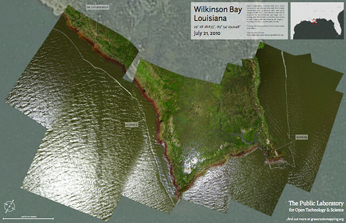
* move the 'oil contamination' label front and center?
* The date needs to be changed to July 22 on the front
* add a mailing address for the "upload this" -- finish PO box
**Post-press**
* distribution plan (didn't liz volunteer)? -- libraries...
* "suggested uses of this data"? -- online resource at /outcomes?
* create a submissions@publiclaboratory.org email address
* create a subscriptions page at /subscriptions
* set up a place to upload images at /analyze
* Can we add an email address that it can get sent to as an alternative to the publiclaboratory page in case there are issues with the upload form?
* URLs we reference:
* http://publiclaboratory.org/wiki/interview-marcotte-2011
* http://publiclaboratory.org/subscribe
* http://publiclaboratory.org/archive
* http://publiclaboratory.org/analysis
* http://grassrootsmapping.org/guide
###Comments###
* (Adam) Overall, I love the map, the idea, and the text, but this text was originally written for a NYTimes OpEd and re-purposed here, right? Although I love it, I think it is bordering on esoteric for the potential map user in the field. It certainly isn't doing any harm there on the map, but if you print it here, you probably can't submit it anywhere else.
###Completed Checklist###
##Planning page for our poster series##
_This project is being led by **Jeff Warren**_
_The current status is:_ laying out and revising the map design and talking to printers
----
###Checklist###
* add full-resolution original image (using low-res version for now)
* "suggested uses of this data"? -- link to online page
* double check URLs
* add "cameras" to front side, like "use balloons, kites, cameras and other simple..."
* move the 'oil contamination' label front and center?
* The date needs to be changed to July 22 on the front
* add a mailing address for the "upload this" -- finish PO box
**Post-press**
* distribution plan (didn't liz volunteer)? -- libraries...
* "suggested uses of this data"? -- online resource at /outcomes?
* create a submissions@publiclaboratory.org email address
* create a subscriptions page at /subscriptions
* set up a place to upload images at /analyze
* Can we add an email address that it can get sent to as an alternative to the publiclaboratory page in case there are issues with the upload form?
* URLs we reference:
* http://publiclaboratory.org/wiki/interview-marcotte-2011
* http://publiclaboratory.org/subscribe
* http://publiclaboratory.org/archive
* http://publiclaboratory.org/analysis
* http://grassrootsmapping.org/guide
###Comments###
* (Adam) Overall, I love the map, the idea, and the text, but this text was originally written for a NYTimes OpEd and re-purposed here, right? Although I love it, I think it is bordering on esoteric for the potential map user in the field. It certainly isn't doing any harm there on the map, but if you print it here, you probably can't submit it anywhere else.
###Completed Checklist###
* dated: "What is lacking is not legibility, but trust. At a town hall..." section
* add "in Fall 2010"
* edit: "...has released numbers identifying Alkylated PAHs and Oil Range Organic Petroleum Hydrocarbons in seafood samples from all the (Delete) areas they tested"
* list resolution & background resolution
* Cyan color matching... talk to printers
* "are there signs of **human** respiratory problems or other **human** health"
* can we delete dead and dying animals and plants? I think ecosystem health covers it.
* instead of "are there signs of respiratory problems..." can we say, "do you remember having respiratory problems or other health effects while near this site?".
* Maybe "visible pollutants and contamination" also covers "oil residue" so that could be cut as well.
* Are we going to mention the LABB in the text? or add any other logos of supporting organizations? **Yes!**
* Inconcise date reference: ten months since when? In the body of the text, change the writing to include a date in this sentence:
We in the Grassroots Mapping community, started as a project at MIT’s Center for Future Civic Media, have spent the last ten months gathering our own data...
* add a license: Public domain for the map, CC-BY-SA for the texts
* regional overview map from Dev. Seed clear map style?
* attribute overview map, background reference map (NAPP?)
* lay out reverse with new size
* a call for "know an area that needs to be mapped?"
* get local description and mappers' names
* "Lauren Craig, Adam Griffith and Kiewit Construction interns"
* Do we need to cite the source of the background imagery?
* there should be two scales, one in meters and one in feet, with each one giving the equivalence in meters, to allow for easy measurement in either set of units and easy conversions
* i was reading "...find out more at grassrootsmapping.org" and wondering about changing it to: "...get m involved at grassrootsmapping.org"
* Isn't this Wilkinson Bay? To connect it to PS- could add Plaquemines Parish
* Also, with the request for people to map other things- can we mention things outside just environmental effects- such as health, how people use the area (ie what the fish there), etc.
* Most people here use the degree system for coordinates- can we add that as well?
* And if people don't mind, I think its always good to have a contact phone number that people can call that connects them to someone. since this is the area I work in, I'm happy using mine for these maps since we dont have a central number- but when are we printing? My number is changing in the next week or so.
* The Public Laboratories logo seems disassociated at lower left, making it both less clear and more heavy-handed.
* Could we combine both text boxes, and if need be, have the scale and north arrow in white in the lower right hand corner? Or maybe just emphasize Public Laboratory in the description text?
* the print is going all the way to the edges of the paper- we can have a full bleed but I think titles and the like should be pulled in 1/2" from the sides- looks like they're a little shy of that.
* can we add a scale in feet as well? it will make the map more accessible to americans.
* didn't we agree to do the compass showing all directions, not just North?
###Printing###
* Oregon Lithoprint design files (color, etc): http://www.oregonlitho.com/resources/olisupportfiles.html
* initial quote: $637.34, 64 cents/map for 1000 -- this will go up with envelopes, folds, paper choices
###Content###
* Public Domain reference imagery to print at 50% opacity behind our maps:
* **This seems to work:** http://tnm2beta.cr.usgs.gov/viewer/ and this: http://edcsns17.cr.usgs.gov/NewEarthExplorer/
* sources for NAIP imagery: http://anygeo.wordpress.com/2006/03/19/free-naip-ortho-imagery-downloads-and-ftp-sites-a-gift-heres-a-ton-of-free-resources-with-ortho-imagery/
* USGS maps, imagery, etc: http://www.usgs.gov/pubprod/aerial.html
* http://eros.usgs.gov/#/Find_Data/Products_and_Data_Available/NAPP
* http://seamless.usgs.gov/