What I want to do
use mapknitter to help people locate the trees that are slated to be destroyed for the (money losing, fun-killing) golf course in city park. I'd like to hold a funeral for the trees, some of which are very old. I'd like to collect the tree ring cores/ disks to demonstrate the age of oak trees.
My attempt and results
i couldn't get the annotation tool to work in windows 8 with chrome. I tried to use the old annotation tool and the new tool. i should try in firefox.
new map http://bitly.com/1KtqDXU
https://mapknitter.org/maps/golf-course-cut-down-city-park-trees
Questions and next steps
If we have to pay for rich people to play golf, we should at least be able to know everything about our trees, since they have to die. for golf.
Why I'm interested
https://www.facebook.com/groups/773913366036920/
https://www.facebook.com/download/849867168407522/NOCPIA-2013financials.pdf
https://www.facebook.com/events/661810927274356


10 Comments
https://www.change.org/p/new-orleans-city-park-cancel-plans-for-development-of-the-championship-level-golf-course-in-northern-city-park?recruiter=25432896&utm_source=share_petition&utm_medium=facebook&utm_campaign=autopublish&utm_term=des-lg-share_petition-reason_msg&fb_ref=Default
Is this a question? Click here to post it to the Questions page.
Reply to this comment...
Log in to comment
http://midcitymessenger.com/2015/02/26/nature-enthusiasts-protest-plans-for-new-championship-level-golf-course-in-city-park/
https://www.facebook.com/groups/WildGolfCourse/
http://www.fox8live.com/clip/11172789/new-golf-course-in-city-park-draws-controversy
Reply to this comment...
Log in to comment
https://www.facebook.com/download/849867168407522/NOCPIA-2013financials.pdf
http://ucmwww.dnr.state.la.us/ucmsearch/UCMRedir.aspx?url=http%3a%2f%2fdnrucm%2fucm%2fgroups%2fcoastalmanagement%2fdocuments%2focm%2f4489493.pdf
http://neworleanscitypark.com/assets/content/site/Master_Plan_City_Park_2018_FINAL.pdf
http://www2.lla.la.gov/HB1/Budget%20Transfers/2586.3353.06302015.Beautification%20and%20Improvement%20of%20New%20Orleans%20City%20Park%20Fund.pdf
Is this a question? Click here to post it to the Questions page.
Reply to this comment...
Log in to comment
http://www.facebook.com/l.php?u=http%3A%2F%2Febird.org%2Febird%2FGuideMe%3Fcmd%3DdecisionPage%26getLocations%3Dhotspots%26hotspots%3DL453412%26yr%3Dall%26m&h=-AQGWRk9w
Is this a question? Click here to post it to the Questions page.
Reply to this comment...
Log in to comment
I got this information from here: http://neworleanscitypark.com/contact Bob Becker, CEO bbecker@nocp.org John Hopper, Director of Public Affairs jhopper@nocp.org Kevin Cox, Chief Financial Officer kcox@nocp.org
Reply to this comment...
Log in to comment
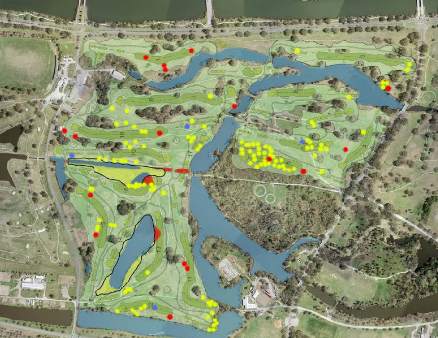
Scott Eustis photo attached of locations of trees to be cut. red are locations of oak trees (17) Scott Eustis's photo. 1 hr · Like
Debra Howell They are NOT supposed to be grabbing part of the natural Couterie Forest land in the middle! Even in the current version of the City Park 2018 master plan, it is not included. (You have to flip the mapknitter image to match it up with all the other maps of City Park) Debra Howell's photo. 48 mins · Edited · Like
Scott Eustis right. I'm very confused about that, Debra. the master plan has two different maps on two different pages. Where did they agree to leave that forest alone? because all of the permits say that they are allowed to cut those 5 acres--they are not protected by regulation. is there a document of that agreement? 35 mins · Like
Debra Howell Not that I know of. I can remember at the time of the downsizing of the golf plans in 2011 that part of the Couterie Forest was shown as taken by golf on the maps done by the golf course designers, but NEVER on the maps presented by City Park. I guess ...See More Debra Howell's photo. 19 mins · Unlike · 1
Scott Eustis right, that's what's confusing in city park papers. the FEMA papers clearly state that those 5.5 acres are golf course 7 mins · Like
Is this a question? Click here to post it to the Questions page.
Reply to this comment...
Log in to comment
http://ucmwww.dnr.state.la.us/ucmsearch/FindDocuments.aspx?idx=xrefnum&val=P20130350&qtype=eq
Is this a question? Click here to post it to the Questions page.
Reply to this comment...
Log in to comment
http://www.fema.gov/media-library-data/20130726-1917-25045-2880/2bdraft_ea_ai_1977_fp_c_city_park_golf_course_reconfiguration.txt
Reply to this comment...
Log in to comment
https://mapknitter.org/maps/hole-5-over-couturie-forest#
Reply to this comment...
Log in to comment
http://bitly.com/1KtqDXU new mapknitter
Reply to this comment...
Log in to comment
Login to comment.