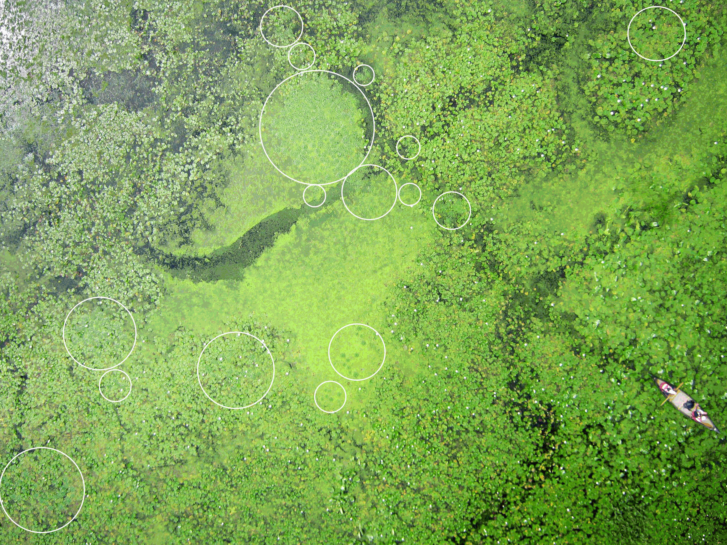
Here is an animated GIF which includes one of the balloon aerial photos we took over Lake Warner, and two other versions of that scene. One is a false color infrared version, and the other is one of Ned Horning's first attempts at classification (grayscale image) to distinguish water chestnut (Trapa natans). The white circles are areas of water chestnut identified by eye in the RGB photo (let me know if you find any more). The dark areas in the grayscale image are areas that Ned's classification determined to be water chestnut. Only Ned knows how he did this. Update: According to Ned, the grayscale image is derived from an image with four channels: red, green, blue, and near infrared. He did a principal components analysis of the data set (four values for each pixel, so about 10 million sets with four values each). Most of the "information" in the image is quantified by the first couple of principal components, and the grayscale image is the fourth principal component. So the brightness of each pixel is determined by the value of the fourth principal component.
The GIF is used as the main image (above) and also the image below to see if either one supports animated GIFs. Please report if either image is not flashing all three versions (green, gray, pink, gray...) in your particular browser. The GIF is made with full resolution versions of the images, but in case this site downsamples them, I attached it to a post at the grassroots mapping forum. However, Google Groups allows only images with fewer than 2000 pixels in either dimension, so that one is not full resolution either. Click the main image above for a reasonably large view of the GIF. Update: Click the main image, right click and save image as... This will download the full resolution GIF (2500x1875). Drag it into a browser to play it.

5 Comments
I want to know more! It seems like there are areas around the canoe which have similar appearance in the gray scale are these water chestnut areas too? Is the water chestnut the black areas in the gray scale image and there are just different densities of water chestnut? Very cool. Would love to hear more. Thanks for sharing. Is this the Warner Lake where the images are from:
https://maps.google.com/maps?q=Warner+Lake,+Massachusetts&ll=42.387966,-72.56916&spn=0.022537,0.045447&client=firefox-a&hnear=Lake+Warner&t=h&z=15
Is this a question? Click here to post it to the Questions page.
Reply to this comment...
Log in to comment
I think the only areas in the image with waterchestnut present are within the white circles. Other areas that are dark in the classification result (grayscale image) are false positives. This was Ned's first try training his magic routines to identify waterchestnut, so the result could get better. You found the correct Lake Warner.
Reply to this comment...
Log in to comment
This isn't actually a classification. I was generating different layers from the 4-band (red, green, blue, near-IR) images collected a few weeks ago to improve classification results and this is one of the images that was created. The generated images included band subtractions, band ratios like NDVI, texture images, and principal component images. The black and white image in Chris' animation is the 4th principal component image derived from the 4-band image. If this highlights water chestnut it's shear luck. I still need to run some experiment with other images (I've only tried two so far) with different resolutions. My expectation is that at the very least this will be an important layer to add to the classification but it might actually be a quick and dirty way to create a nice overview of likely water chestnut areas. An option for creating principal component images can be added to the plugin if there's an interest.
Reply to this comment...
Log in to comment
This looks very encouraging as a possible tool for those of us trying to locate and control water chestnut. Since I haven't been involved since the day in the field when the photos were taken, I am wondering if the GPS points taken of water chestnut were used to verify these locations identified in the photo classification.
Reply to this comment...
Log in to comment
Hi Cynthia, We got several GPS locations from patches of water chestnut, but I have not yet matched up the field descriptions with the GPS coordinates (I am not sure which field sheet goes with which coords). However, this is not very critical because we have lower altitude photos in which you can clearly distinguish water chestnut from everything else growing there. So we know exactly where it is in many of the photos. Ned is now focusing on the task of machine identification, and we can use the photos as confirmation.
I am interested to hear whether you and Nate and Colleen think you harvested all of the water chestnut circled in the photo above and in the other photos here.
Reply to this comment...
Log in to comment
Login to comment.