
Friends thanks for everyone's interest! I would like to bring into sharp focus our information by category by era, and interactIon with nature. Please please note gaps and data quality observations and suggestions to your heart's contents
I AM LINKING USEFUL DATA TO THE LIST BELOW . HELP IT BE JUST WHAT EPA NEEDS. (More to come) What EPA is looking for See page 6 of that pdf
GOAL Supply US EPA with sufficient well organized information for them to feel reasonably certain that they understand the nature of the anthropogenic impacts to that intertidal wetland and water body when they carry out their preliminary screening.
GAC CHEMICAL - RELATED DATA AND INFO ARCHIVE Here's the disorderly lot. Note: that Delta Chemical is the predecessor to GAC Chemical - from 1970 when shore-dumping halted more or less to 1995, when GAC CHemical took over. Pray click about in that and help select the best - nearly every file is filename-explanatory and we'll post it here.
GAC's waste discharge licenses & related docs GAC MEPDES permit 2012 *** GAC MEPDES Permit 2006 Non-POTW Waste Discharge licenses. GAC on page 15 1998 DEP Notice of Violation. 1998 Response to Notice of Violation Maine DEP's google earth site mapping state permits licenses, wildlife and pollution areas
AT ISSUE 6/1/12 FOPB letter to GAC Chemical 10/18/13 MDEP Site Walk report 10/11/13 DEP slideshow 11/18/13 FOPB Response to MDEP site walk report.
EMAIL TRAFFIC http://penbay.org/gac/gac_2014/fopb_118113_ltr_dep.pdf
PHOTOGRAPHS SATELLITE AND AERIAL High altitude photography 1940 to 1980; Google earth images 1990s to present; Lower level aerial photography, 1990s - present. Groundlevel photography 1990s to present.
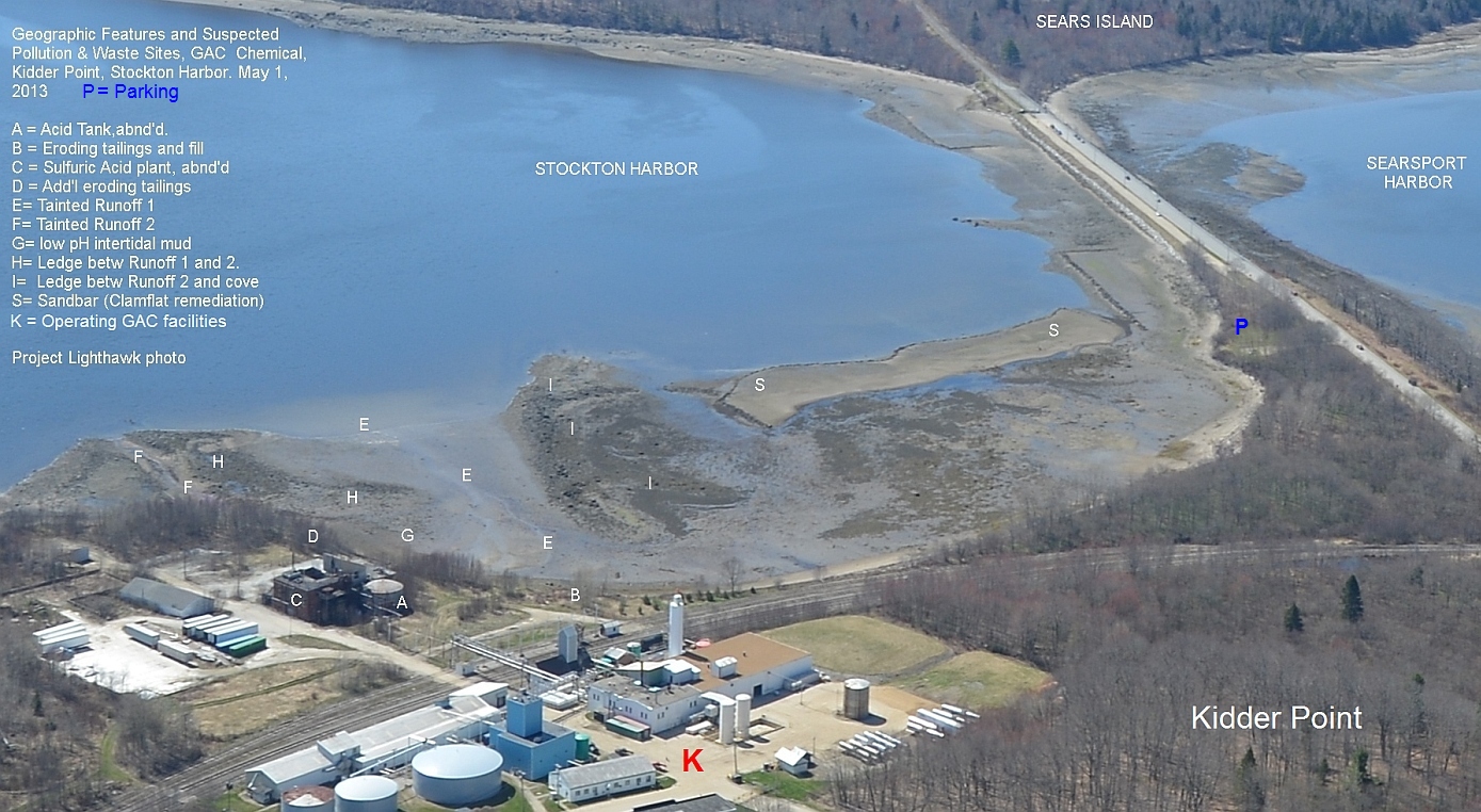
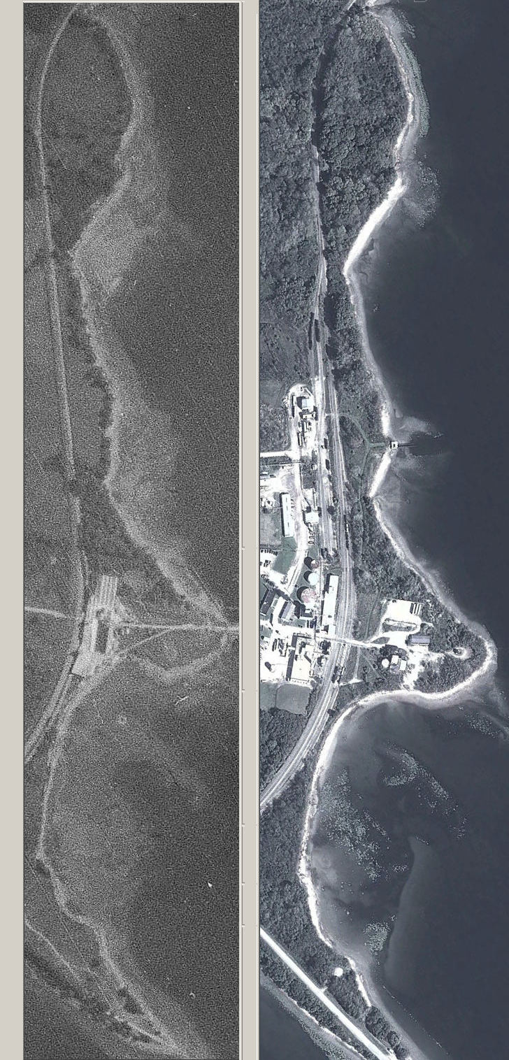
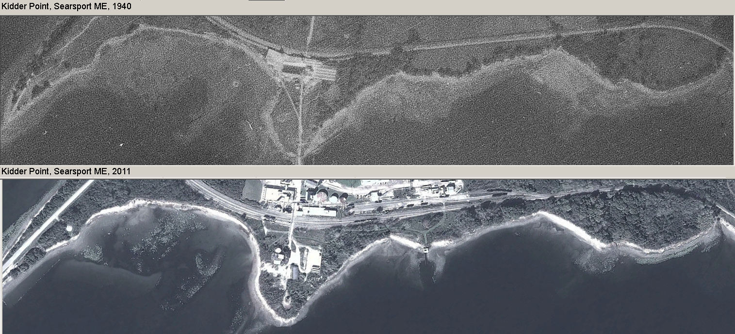
Aerial photo of GAC Chemical and impacted cove with captions 1940 & 2011 aerial photo coastline comparison. Vertical Larger 1940-2011 vertical coastal Horizontal 1940-2011 comparison
MAPS & MODELS. Prehistory, colonial state and naval maps. NOAA maps agency agency maps company maps
PAST POLLUTION & WASTE REPORTS BY AGENCIES http://penbay.org/gac/gac_2014/fopb_118113_ltr_dep.pdf
Maine DEP/USEPA. USFWS/DIFW. NOAA/DMR
NEWS MEDIA COVERAGE 1902 - PRESENT
1 Comments
Ron this is super interesting great work. I'm looping in @Eymund who has gathered similar historical, geographic, and community-produced data to inform EPA region 2.
Reply to this comment...
Log in to comment
Login to comment.