What we want to do
At Basurama we were invited to participate in an art exhibition in the EACC (Castellón), and we develop a project to fit the exhibition and our purposes: we wanted to start a local chapter of balloon&kite mappers in Spain and awake the inactive email list in Spanish. To fulfill our goals we organized a 3 day workshop with local groups to produce 3 local maps (January 31st - february 2nd).
It was a great time in Castellón. We were able to show how to do balloon mapping to a wide range of people (activists, photographers, mappers) and start a small community of users, let’s see how it develops.
You can check the website with maps and photos of the “Defiende el territorio desde el aire” project (in Spainsh).
Our attempt and results
1. Preproduction
We bought 2 balloon mapping kits (with and without kites) and 2 extra balloons from the Public Lab store. We discovered a week before the workshop that the packages was held in customs, we had to pay taxes (74€).
We bought 2 compact cameras: the Canon Powershot a1300 and a1400 (165€) and 16Gb SD cards and rechargeable batteries.
We bought the helium and transported it in a big rented van that could fit the balloon when inflated, so to avoid inflating and deinflating it.
2. Contact local groups
We made a public call and emailed/phone called different local environmental groups and citizens. We asked them which places they would be interested to map and made collaboratively a list with potential locations to map. We wanted to support local struggles that were already engaged with the defense of the territory. Castellón region is a good example in Spain to show the destruction the real estate bubble caused.
We got some groups engaged in the project in Valencia and Castellón:
- In El Saler village, a local organization was fighting to revert the construction of road into a street to recover their historic access to their harbour lake. Map available.
- In Castellón, a local ecologist group was interested in having a look to what was happening in an industrial area (El Serrallo) in the harbour that contained a BP refinery, an incinerator plant for dangerous substances, and two thermal plants. Map available.
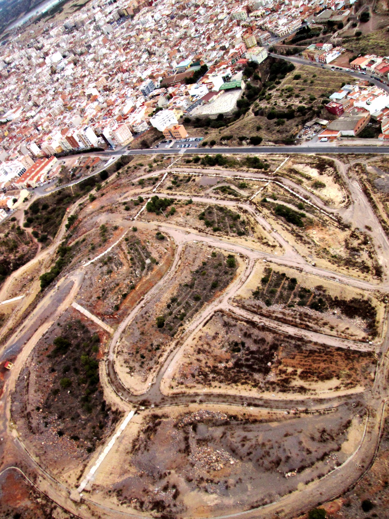
- A new residential area was going to be built, but it got stopped and left a “broken” mountain at the north of La Vall d’Uixó. Map available. The local group of Ecologistes en Acció is planning to use the photos for their mobilizations.
3. The workshop: theory and practice
We split the workshop in parts:
Theory (indoors):
Friday afternoon we organized a 3 hour workshop on:
- introduction to Basurama, Public Lab and 6000km project.
- digital cartographies (Open Street Map, GPS traces, layers)
- aerial photography (passenger pigeon, pole photography, and ballon mapping)
- a mapknitter session with existing photos from mapmill (Tidmarsh Farm)
- free licensing theory, open research
- discussion on which locations to map. Local groups told what was interesting for them.
Around 20 people showed up: ecologists, artists and local activists. Ecologistes en Acció del País Valencià y Molts Mons.
Practice (outdoors):
On Saturday (10am until sunset at 6pm) we made a session in Castellón outskirts with all the participants from Friday, We taught how to build a rig and inflate a balloon. We made our first flights in the vicinity of the refinery, El Serrallo. We only could get the border of such a huge industrial area, wind didn't help
After a good paella lunch we continued mapping in Moncofar, in one of those places where streets have been built, but no buildigns are around. We got many motion blurred pictures (we had wrongly set the mode of the camera to aperture mode), not enought to build a good map.
After every flight we downloaded the images to our laptop and to the laptop of one of the participants. For next time we have to remember to tell participants to bring their own laptops, usb or hard drives to bring the images home with them. Later on it is much more complicated to transfer so many images (6200 images that day, 6 flights in 2 locations, 15.3GB). There was not enough wind to fly kites.

Results were great but we were concerned with the lack of sharpness of the images, check the thread about this in the Grassroots Mapping list. Cheap Canon powershot a1400 and a1300 are great, but not the best quality. The final maps looked good, though!
In some of the images, because of the strong wind (or other deffect), the camera moved inside the 5 liter water PET Bottle with the Rubber Band Rig, and we got some or the corners of the images with the bottle. we tried in the next flights to fix the camera better.

On Sunday we travelled 1 hour south, to the outskirts of Valencia city, to El Saler to map the CV-500 road that separated since decades villagers from their lake. After a quick introduction (a short version of the Friday workshop + how to build a rig) in the indoors space of the local association we started mapping. We made a boat trip to map the road and the lake as well.

The regional association of associations Avinença had announce the workshop and many people (around 50) came to the workshop. It was difficult to manage such a big group. Our plan was to use the 2 kits and split the group in two, but one of the cameras was missing! It appeared later inside a bag… keep your cameras close!
After a brief meal in a bar we tried to find a place were to show the photos and make a quick demonstration with mapknitter. (5 fligths in one location, 5291 photos, 14.7GB).

4. Postproduction
After 3 days of intense flying and workshopping we still had to select and knit and print the maps for the exhibition. We made an extra flight in La Vall d’Uixó to be sure we had good images!
Though every night after flying we had ordered the images, we still had to select the good ones and decide which ones could be good enough to build a map. We wanted to make this process collaboratively with local groups, but due to the short time we had left we had to do it on our own (we had to come leave Castellón) Rubén and me, the Basurama team at Castellón.
After a long mapknitting session until late that night we started exporting the three maps. We had some problems with the tool crashing, better export them one at a time.
Next morning we continue fixing some errors in the maps and exporting. Later on we used Inkscape to prepare the maps for printing: add scale, north and explanatory text. Ready for print in 1.2x1.2m paper and hang onto the wall.

For next time it would be better to to some extra time to make a mapknitting session with the participants, otherwise they don’t get a sense of the whole process (though we have explained it) and maps appear magically finished!
5. Exhibition

The collective exhibition was opening on Friday night, the day the workshop was starting. We displayed previous related maps and a note on the wall saying that we would print the results of the workshop.

Our section displayed:
- Previous maps: Saugus Landfill (MA, USA), Ruins of PAU ensanche Vallecas (Madrid, Spain).
- Balloon and kite mapping kit
- Google maps and Bing aerial photographs of the locations local groups wanted to map.
- List of the locations local groups wanted to map
- Screen with photos of the workshop
- Maps, results of the workshop
- Balloon (while the helium inside lasted)
Questions and next steps

The public Public Lab balloon mapping kit
One of the main goals was to build a local community of balloon mappers. One kit with a camera and a bottle rig remained in the exhibition space, and the other ready for the participants to use during the 3 months that the exhibition lasts, until April 27th 2014. Many people got excited during the workshop, but then we know that it is not easy, even when you have the kit, to organize a flight. Let’s see how it works.
This weekend one of the local groups is planning to use it in an event against fracking. As they can’t afford buying helium, they will try to fly the kite. Let’s hope there is wind enough!
Transporting the inflated balloon
We only needed to inflate one balloon for all the flights throughout the weekend. We just needed a big van to transport it. Totally recommend this option to share helium costs.
Starting a local chapter
We’ve encouraged people to submit their doubts, flights and ideas to the Spanish Public Lab email list, but they keep writing to us. I’ve see this problem before, maybe a good method is to answer them cc’ing the eail list, though I have some privacy concerns with their emails addresses.
We opened a gdoc with information about flying balloons in Spain, we don’t know if to move the content to the Public Lab wiki or leave it there, until there is multilanguage support.
Intensive workshop + Exhibition
We think it is a great format that we once explored in the Trans Trash exhibition that we organized at MIT. Making the trip, mapknitting and hanging it on the wall in a short period of time is a great example to show the potential of the tool. The only problem is that you need time. If we had only flown one day (Saturday) and dedicated Sunday to mapknitting, we could've made a mapknitting session with the group with the local photos, at the expense of not mapping that day. Anyways, mounting three maps ready for an exhibiton in one day might be too short time!
Map exhibition
I don’t know if it has been commented/done before, but the Public Lab map archive has a great potential to be exhibited and show the power of the tool. I’ll be willing to cordinate and think about this if someone is interested.
Drones joined us
Lot, a participant in the workshop, brought his own self-made drone. On Sunday another participant made a flight with another drone and filmed with it. You can see in a video how we are about to leave with the boat with the balloon in El Saler. We had interesting discussions about pros and cons of drone flying, but from my point of view, the overall idea many people get is that drones are “the next step” in balloon mapping. People get fascinated with the buzz and movements of those machines and forget about kites!
Buying in the Public Lab store in Europe
As I commented, to pay extra taxes in customs makes buying overseas complicated for people outside the US. If there is enough interest in Europe, we could think of starting a local distribution… maybe starting a crowdfunding campaign to measure the need of it? I guess we should first explore the market and see what's out there.
More images of the workshop


Mapping in El Saler and l'Albufera

You can see the banner of the local organization on the ground, talking about the road CV-500 they are fighting against.


Mapping in Moncofar


Mapping in La Vall d'Uixó


The other two maps:
El Serrallo

The road CV-500 that separates El Saler from the lake

Thanks
Thanks to the Public Lab community for helping us think and organize this set of activities. Thanks to Lot for helping with the photos of the workshop.
Crossposted at basurama.org
13 Comments
Thank you for posting about these community mapping activities. I was excited about your post and quickly added these 2 maps to the Public Lab Map Archive: | El Serrallo | El Saler
Reply to this comment...
Log in to comment
The La Vall d'Uixó map is great too, but the image in the far Northeast corner of the map is more oblique angle than the rest of the map so it might work best to export a vertical map of the scene that does not include that one image.
Reply to this comment...
Log in to comment
It is true about that image. The slope was big and we had no better photo of that part of the mountain. http://numeroteca.org/wp-content/uploads/2014/02/mountain-distorted-photo.png
It was geometricaly incorrect. We just tried to make things fit. Apart from removing the image, I thought on splitting the image in two and knit again. The other solution is to get more height in the photos, I guess. Have you faced a similar problem?
Is this a question? Click here to post it to the Questions page.
Reply to this comment...
Log in to comment
Great gonzoearth about seeing the maps published in the Public Lab archive. Two things: they don't show up yet in the map with all the other maps, and if we remake them (fix some prolems), how is the process of exporting them again to the Public Lab archive? Thanks.
Is this a question? Click here to post it to the Questions page.
Reply to this comment...
Log in to comment
Removing part of the image is a good plan. It is very common to have a non-vertical angle on the backside of a 3D structure (hillside). It is usually a balance of fitting the imagery but also including as much area as possible. Oblique aerial images can also be placed in 3D overlay in Google Earth (virtual globe).
Reply to this comment...
Log in to comment
The Map Archive map is still in development and I am not sure why the pin markers do not all show up, we will get it fixed :) The Archive pages can be updated as needed if the cartography on MapKnitter continues. Think of it as a separate data store/library, different from what is stored on MapKnitter.org.
Reply to this comment...
Log in to comment
It is so wonderful to see your whole workshop documented. thanks Pablo, this is really excellent. awesome maps too!
Reply to this comment...
Log in to comment
Very nice results, excellent.
Reply to this comment...
Log in to comment
Thank you for sharing your workshop design--it is very strategic where there are many stakeholder groups who can come together around a shared project. I appreciate how you articulated your goals, one of which was to "build a local community of balloon mappers", and how already there are plans for more aerial mapping by a local anti-fracking activist group.
I also have a question for you: do you see the laboratoriopublico list as a global list in Spanish language, or geographically specific to spain?
Is this a question? Click here to post it to the Questions page.
Reply to this comment...
Log in to comment
Hi Liz, we asked ourselves that same question about the laboratoriopublico email list. Still unclear!
Now, people participating in the list are from Spain, but potentially (and in the past with Perú) it is for anyone speaking in Spanish. We'd love to see people from other regions. I guess we have to see how it develops and then decide its future. Your thoughts?
Is this a question? Click here to post it to the Questions page.
Reply to this comment...
Log in to comment
oh that's great to hear about your process on this. There's a group of Brazilians who are moving towards a portuguese language mailing list, and we are musing about whether to name it as "-Brasil" to indicate a regional group, or name it with emphasis on the portuguese language, which would theoretically enable a more global useage. Although i would be so excited to have a global portuguese language list, i think what this is, in fact, is a regional list that happens to employ a non-english language.
Pragmatically, it seems that the first place of connection for both spanish and portuguese speakers will be these language-specific lists, even if most of the time they serve a regional purpose. That seems perfectly fine to me, how about you?
Is this a question? Click here to post it to the Questions page.
Reply to this comment...
Log in to comment
I think it will be difficult to have a multi-thematic Spanish list. I guess people usually will go to the theme specific lists, even if they are in English. My second guess is that the laboratoriopublico list will be centered in balloon mapping and Spain, but I also agree that they can be a good introduction to Public Lab for non-english speakers. It can also be a good chanel to present other non-balloon mapping projects to the Spanish (and Spanish speaking) community. I think other non balloon mapping projects are not that known.
Reply to this comment...
Log in to comment
This sounds great Pablo! FYI, it sounds like "laboratoriopublico-portugues" is the preferred name for the new Brazilian list.
Reply to this comment...
Log in to comment
Login to comment.